Zelenoborskiy geodata
Zelenoborskiy (Murmansk) is a populated place; located in Russia in Europe/Moscow (GMT+3) time zone. With population of 7,207 people, there are 1950 cities with bigger population in this country. Compared to other cities in Russia, 98.4% of cities are located further ↓South; 92.9% of cities are located further →East and 79.6% of cities have higher elevation than Zelenoborskiy. Note1


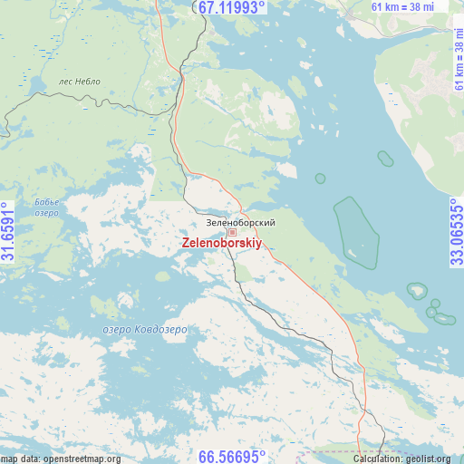
Zelenoborskiy GPS coordinates[2]
66° 50' 42" North, 32° 21' 43.992" East
| Map corner | latitude | longitude |
|---|---|---|
| Upper-left | 67.11993°, | 31.6591° |
| Center: | 66.845°, | 32.36222° |
| Lower-right: | 66.56695°, | 33.06535° |
| Map W x H: | 61.5×61.5 km | = 38.2×38.2mi |
| max Lat: | 73.50819° ⇑1.6% North |
| Zelenoborskiy: | 66.845° |
| min Lat: | ⇓98.4% South 41.28413° |
| min Long | Zelenoborskiy | max Long |
| -179.12198° | 32.36222° | 179.35046° |
| W 7.1%⇐ | ⇒92.9% E |
Elevation
Elevation of Zelenoborskiy is 72 m = 236 ft, and this is 130.6 m = 428 ft below average elevation for this country.
| Max E: |
2518 m = 8261 ft | 79.6% |
| Avg. | 202.6 m = 665 ft | |
| Zelenoborskiy | 72 m = 236 ft | |
Min E: |
-28 m = -92 ft | 20.4% |
See also: Russia elevation on elevation.city.
Geographical zone
Zelenoborskiy is located in North Frigid zone (between North Pole and Arctic Circle). Distance of this North polar circle is 31.3 km =19.4 mi to South.| Distance of | km | miles | from Zelenoborskiy |
|---|---|---|---|
| North Pole | 2574.6 | 1599.8 | to North |
| Arctic Circle | 31.3 | 19.4 | to South |
| Tropic Cancer | 4826.5 | 2999 | to South |
| Equator | 7432.5 | 4618.3 | to South |


Nearby cities:
15 places around Zelenoborskiy: (largest is in red/bold)
• Afrikanda
68.9 km =42.8 mi,  15°
15°
• Alakurtti
88.8 km =55.2 mi,  278°
278°
• Ambarnyy
121.8 km =75.7 mi,  150°
150°
• Apatity
91.7 km =57 mi,  29°
29°
• Chupa
70.9 km =44.1 mi, 154°
• Kandalaksha
35.3 km =21.9 mi,  3°
3°
• Kirovsk
102.5 km =63.7 mi, 33°
• Koashva
116.6 km =72.5 mi,  39°
39°
• Kovdor
114.2 km =71 mi,  314°
314°
• Loukhi
90.7 km =56.4 mi,  160°
160°
• Monchegorsk
123.7 km =76.9 mi,  10°
10°
• Polyarnyye Zori
58.2 km =36.2 mi, 5°
• Poyakonda
34.4 km =21.4 mi,  144°
144°
• Umba
88.6 km =55.1 mi,  101°
101°
• Zasheyek
62.7 km =39 mi, 7°
Sources, notices
• [Note1] Compared only with cities in Russia existing in our database
• [Src1] Map data: © OpenStreetMap contributors (CC-BY-SA)
• [Src2] Other city data from geonames.org with taken over terms of usage.
• [Src3] Geographical zone / Annual Mean Temperature by Robert A. Rohde @ Wikipedia
