Afrikanda geodata
Afrikanda (Murmansk) is a populated place; located in Russia in Europe/Moscow (GMT+3) time zone. With population of 1,800 people, there are 4252 cities with bigger population in this country. Compared to other cities in Russia, 98.6% of cities are located further ↓South; 92.3% of cities are located further →East and 53.1% of cities have higher elevation than Afrikanda. Note1


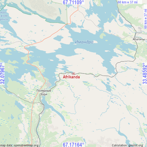
Afrikanda GPS coordinates[2]
67° 26' 34.404" North, 32° 46' 58.044" East
| Map corner | latitude | longitude |
|---|---|---|
| Upper-left | 67.71109°, | 32.07967° |
| Center: | 67.44289°, | 32.78279° |
| Lower-right: | 67.17164°, | 33.48592° |
| Map W x H: | 60×60 km | = 37.3×37.3mi |
| max Lat: | 73.50819° ⇑1.4% North |
| Afrikanda: | 67.44289° |
| min Lat: | ⇓98.6% South 41.28413° |
| min Long | Afrikanda | max Long |
| -179.12198° | 32.78279° | 179.35046° |
| W 7.7%⇐ | ⇒92.3% E |
Elevation
Elevation of Afrikanda is 138 m = 453 ft, and this is 64.6 m = 212 ft below average elevation for this country.
| Max E: |
2518 m = 8261 ft | 53.1% |
| Avg. | 202.6 m = 665 ft | |
| Afrikanda | 138 m = 453 ft | |
Min E: |
-28 m = -92 ft | 46.9% |
See also: Russia elevation on elevation.city.
Geographical zone
Afrikanda is located in North Frigid zone (between North Pole and Arctic Circle). Distance of this North polar circle is 97.8 km =60.8 mi to South.| Distance of | km | miles | from Afrikanda |
|---|---|---|---|
| North Pole | 2508.1 | 1558.5 | to North |
| Arctic Circle | 97.8 | 60.8 | to South |
| Tropic Cancer | 4893 | 3040.4 | to South |
| Equator | 7498.9 | 4659.6 | to South |


Nearby cities:
15 places around Afrikanda: (largest is in red/bold)
• Apatity
29.6 km =18.4 mi,  62°
62°
• Kandalaksha
35 km =21.7 mi,  206°
206°
• Kirovsk
42.4 km =26.3 mi, 63°
• Koashva
60 km =37.3 mi,  66°
66°
• Kovdor
99.1 km =61.6 mi,  277°
277°
• Lovozero
113.1 km =70.3 mi, 56°
• Monchegorsk
55.4 km =34.4 mi,  3°
3°
• Olenegorsk
80.3 km =49.9 mi,  14°
14°
• Polyarnyye Zori
14.9 km =9.3 mi,  234°
234°
• Poyakonda
94.4 km =58.7 mi,  178°
178°
• Revda
93 km =57.8 mi,  53°
53°
• Umba
107.8 km =67 mi,  141°
141°
• Vysokiy
81.6 km =50.7 mi,  19°
19°
• Zasheyek
10.9 km =6.8 mi,  246°
246°
• Zelenoborskiy
68.9 km =42.8 mi,  195°
195°
Sources, notices
• [Note1] Compared only with cities in Russia existing in our database
• [Src1] Map data: © OpenStreetMap contributors (CC-BY-SA)
• [Src2] Other city data from geonames.org with taken over terms of usage.
• [Src3] Geographical zone / Annual Mean Temperature by Robert A. Rohde @ Wikipedia
