Umba geodata
Umba (Murmansk) is a populated place; located in Russia in Europe/Moscow (GMT+3) time zone. With population of 6,128 people, there are 2223 cities with bigger population in this country. Compared to other cities in Russia, 98.4% of cities are located further ↓South; 89.9% of cities are located further →East and 98.8% of cities have higher elevation than Umba. Note1


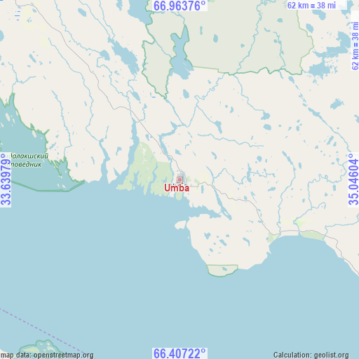
Umba GPS coordinates[2]
66° 41' 13.416" North, 34° 20' 34.476" East
| Map corner | latitude | longitude |
|---|---|---|
| Upper-left | 66.96376°, | 33.63979° |
| Center: | 66.68706°, | 34.34291° |
| Lower-right: | 66.40722°, | 35.04604° |
| Map W x H: | 61.9×61.9 km | = 38.5×38.5mi |
| max Lat: | 73.50819° ⇑1.6% North |
| Umba: | 66.68706° |
| min Lat: | ⇓98.4% South 41.28413° |
| min Long | Umba | max Long |
| -179.12198° | 34.34291° | 179.35046° |
| W 10.1%⇐ | ⇒89.9% E |
Elevation
Elevation of Umba is 1 m = 3 ft, and this is 201.6 m = 661 ft below average elevation for this country.
| Max E: |
2518 m = 8261 ft | 98.8% |
| Avg. | 202.6 m = 665 ft | |
| Umba | 1 m = 3 ft | |
Min E: |
-28 m = -92 ft | 1.2% |
See also: Russia elevation on elevation.city.
Geographical zone
Umba is located in North Frigid zone (between North Pole and Arctic Circle). Distance of this North polar circle is 13.7 km =8.5 mi to South.| Distance of | km | miles | from Umba |
|---|---|---|---|
| North Pole | 2592.2 | 1610.7 | to North |
| Arctic Circle | 13.7 | 8.5 | to South |
| Tropic Cancer | 4809 | 2988.2 | to South |
| Equator | 7414.9 | 4607.4 | to South |


Nearby cities:
15 places around Umba: (largest is in red/bold)
• Afrikanda
107.8 km =67 mi,  321°
321°
• Ambarnyy
92.2 km =57.3 mi,  197°
197°
• Apatity
105.6 km =65.6 mi,  337°
337°
• Chupa
73.6 km =45.7 mi,  230°
230°
• Engozero
101.8 km =63.3 mi,  190°
190°
• Kandalaksha
99.3 km =61.7 mi,  302°
302°
• Kirovsk
107.1 km =66.5 mi, 344°
• Koashva
108.3 km =67.3 mi,  354°
354°
• Loukhi
89.1 km =55.4 mi,  220°
220°
• Lovozero
149.5 km =92.9 mi,  11°
11°
• Polyarnyye Zori
110 km =68.4 mi,  313°
313°
• Poyakonda
67.9 km =42.2 mi,  261°
261°
• Revda
139.3 km =86.6 mi,  3°
3°
• Zasheyek
111.4 km =69.2 mi, 315°
• Zelenoborskiy
88.6 km =55.1 mi,  281°
281°
Sources, notices
• [Note1] Compared only with cities in Russia existing in our database
• [Src1] Map data: © OpenStreetMap contributors (CC-BY-SA)
• [Src2] Other city data from geonames.org with taken over terms of usage.
• [Src3] Geographical zone / Annual Mean Temperature by Robert A. Rohde @ Wikipedia
