Kandalaksha geodata
Kandalaksha (Murmansk) is a populated place; located in Russia in Europe/Moscow (GMT+3) time zone. With population of 38,431 people, there are 543 cities with bigger population in this country. Compared to other cities in Russia, 98.5% of cities are located further ↓South; 92.8% of cities are located further →East and 87% of cities have higher elevation than Kandalaksha. Note1


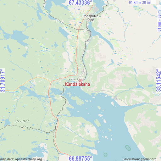
Kandalaksha GPS coordinates[2]
67° 9' 43.2" North, 32° 24' 44.244" East
| Map corner | latitude | longitude |
|---|---|---|
| Upper-left | 67.43336°, | 31.70917° |
| Center: | 67.162°, | 32.41229° |
| Lower-right: | 66.88755°, | 33.11542° |
| Map W x H: | 60.7×60.7 km | = 37.7×37.7mi |
| max Lat: | 73.50819° ⇑1.5% North |
| Kandalaksha: | 67.162° |
| min Lat: | ⇓98.5% South 41.28413° |
| min Long | Kandalaksha | max Long |
| -179.12198° | 32.41229° | 179.35046° |
| W 7.2%⇐ | ⇒92.8% E |
Elevation
Elevation of Kandalaksha is 40 m = 131 ft, and this is 162.6 m = 533 ft below average elevation for this country.
| Max E: |
2518 m = 8261 ft | 87% |
| Avg. | 202.6 m = 665 ft | |
| Kandalaksha | 40 m = 131 ft | |
Min E: |
-28 m = -92 ft | 13% |
See also: Russia elevation on elevation.city.
Geographical zone
Kandalaksha is located in North Frigid zone (between North Pole and Arctic Circle). Distance of this North polar circle is 66.5 km =41.3 mi to South.| Distance of | km | miles | from Kandalaksha |
|---|---|---|---|
| North Pole | 2539.3 | 1577.8 | to North |
| Arctic Circle | 66.5 | 41.3 | to South |
| Tropic Cancer | 4861.8 | 3021 | to South |
| Equator | 7467.7 | 4640.2 | to South |


Nearby cities:
15 places around Kandalaksha: (largest is in red/bold)
• Afrikanda
35 km =21.7 mi,  26°
26°
• Alakurtti
92 km =57.2 mi,  256°
256°
• Apatity
61.6 km =38.3 mi,  43°
43°
• Chupa
103.1 km =64.1 mi,  164°
164°
• Kirovsk
73.7 km =45.8 mi,  46°
46°
• Koashva
90 km =55.9 mi, 52°
• Kovdor
94.3 km =58.6 mi,  298°
298°
• Monchegorsk
88.7 km =55.1 mi,  12°
12°
• Olenegorsk
114.7 km =71.3 mi,  18°
18°
• Polyarnyye Zori
23 km =14.3 mi, 9°
• Poyakonda
65.6 km =40.8 mi, 164°
• Umba
99.3 km =61.7 mi,  122°
122°
• Vysokiy
116.3 km =72.3 mi, 21°
• Zasheyek
27.5 km =17.1 mi, 12°
• Zelenoborskiy
35.3 km =21.9 mi,  183°
183°
Sources, notices
• [Note1] Compared only with cities in Russia existing in our database
• [Src1] Map data: © OpenStreetMap contributors (CC-BY-SA)
• [Src2] Other city data from geonames.org with taken over terms of usage.
• [Src3] Geographical zone / Annual Mean Temperature by Robert A. Rohde @ Wikipedia
