Perevoloki geodata
Perevoloki (Samara Oblast) is a populated place; located in Russia in Europe/Samara (GMT+4) time zone. With population of 1,130 people, there are 4560 cities with bigger population in this country. Compared to other cities in Russia, 60.9% of cities are located further ↑North; 61% of cities are located further ←West and 82.2% of cities have higher elevation than Perevoloki. Note1


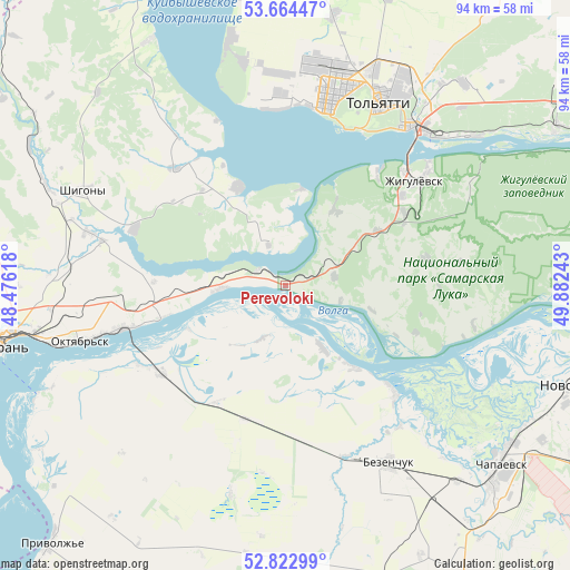
Perevoloki GPS coordinates[2]
53° 14' 44.88" North, 49° 10' 45.48" East
| Map corner | latitude | longitude |
|---|---|---|
| Upper-left | 53.66447°, | 48.47618° |
| Center: | 53.2458°, | 49.1793° |
| Lower-right: | 52.82299°, | 49.88243° |
| Map W x H: | 93.6×93.6 km | = 58.2×58.2mi |
| max Lat: | 73.50819° ⇑60.9% North |
| Perevoloki: | 53.2458° |
| min Lat: | ⇓39.1% South 41.28413° |
| min Long | Perevoloki | max Long |
| -179.12198° | 49.1793° | 179.35046° |
| W 61%⇐ | ⇒39% E |
Elevation
Elevation of Perevoloki is 62 m = 203 ft, and this is 140.6 m = 461 ft below average elevation for this country.
| Max E: |
2518 m = 8261 ft | 82.2% |
| Avg. | 202.6 m = 665 ft | |
| Perevoloki | 62 m = 203 ft | |
Min E: |
-28 m = -92 ft | 17.8% |
See also: Russia elevation on elevation.city.
Geographical zone
Perevoloki is located in North temperate zone (between Tropic of Cancer and the Arctic Circle). Distance of this North polar circle is 1480.8 km =920.1 mi to North.| Distance of | km | miles | from Perevoloki |
|---|---|---|---|
| North Pole | 4086.7 | 2539.4 | to North |
| Arctic Circle | 1480.8 | 920.1 | to North |
| Tropic Cancer | 3314.5 | 2059.5 | to South |
| Equator | 5920.4 | 3678.8 | to South |


Nearby cities:
15 places around Perevoloki: (largest is in red/bold)
• Bakhilovo
34.9 km =21.7 mi,  60°
60°
• Bezenchuk
33.9 km =21.1 mi,  149°
149°
• Bol’shaya Ryazan’
8.3 km =5.2 mi,  80°
80°
• Chapayevsk
46.3 km =28.8 mi,  130°
130°
• Mezhdurechensk
5.1 km =3.2 mi,  297°
297°
• Obsharovka
25.6 km =15.9 mi,  238°
238°
• Oktyabr’sk
33.1 km =20.6 mi,  254°
254°
• Podstepki
30.1 km =18.7 mi,  354°
354°
• Shigony
36.9 km =22.9 mi, 295°
• Syzran’
48.4 km =30.1 mi,  258°
258°
• Tol’yatti
33.5 km =20.8 mi,  19°
19°
• Valy
17.4 km =10.8 mi, 59°
• Zhigulevsk
27.1 km =16.8 mi,  50°
50°
• Zhiguli
14.9 km =9.3 mi,  32°
32°
• Zol’noye
46.5 km =28.9 mi, 62°
Sources, notices
• [Note1] Compared only with cities in Russia existing in our database
• [Src1] Map data: © OpenStreetMap contributors (CC-BY-SA)
• [Src2] Other city data from geonames.org with taken over terms of usage.
• [Src3] Geographical zone / Annual Mean Temperature by Robert A. Rohde @ Wikipedia
