Bol’shaya Ryazan’ geodata
Bol’shaya Ryazan’ (Samara Oblast) is a populated place; located in Russia in Europe/Samara (GMT+4) time zone. With population of 924 people, there are 4687 cities with bigger population in this country. Compared to other cities in Russia, 60.7% of cities are located further ↑North; 61.2% of cities are located further ←West and 51.9% of cities have lower elevation than Bol’shaya Ryazan’. Note1


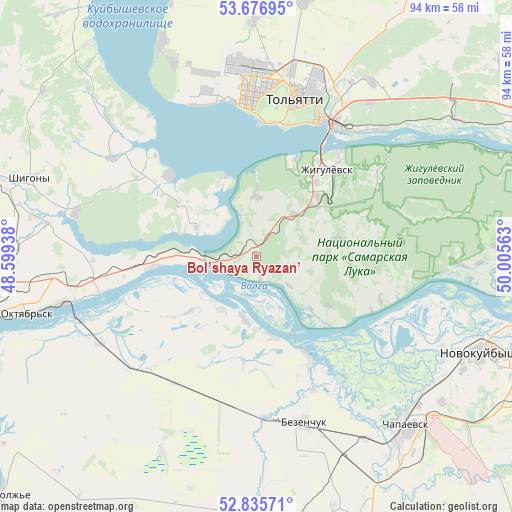
Bol’shaya Ryazan’ GPS coordinates[2]
53° 15' 30.24" North, 49° 18' 9" East
| Map corner | latitude | longitude |
|---|---|---|
| Upper-left | 53.67695°, | 48.59938° |
| Center: | 53.2584°, | 49.3025° |
| Lower-right: | 52.83571°, | 50.00563° |
| Map W x H: | 93.5×93.5 km | = 58.1×58.1mi |
| max Lat: | 73.50819° ⇑60.7% North |
| Bol’shaya Ryazan’: | 53.2584° |
| min Lat: | ⇓39.3% South 41.28413° |
| min Long | Bol’shaya Rya | max Long |
| -179.12198° | 49.3025° | 179.35046° |
| W 61.2%⇐ | ⇒38.8% E |
Elevation
Elevation of Bol’shaya Ryazan’ is 149 m = 489 ft, and this is 53.6 m = 176 ft below average elevation for this country.
| Max E: |
2518 m = 8261 ft | 48.1% |
| Avg. | 202.6 m = 665 ft | |
| Bol’shaya Ryazan’ | 149 m = 489 ft | |
Min E: |
-28 m = -92 ft | 51.9% |
See also: Russia elevation on elevation.city.
Geographical zone
Bol’shaya Ryazan’ is located in North temperate zone (between Tropic of Cancer and the Arctic Circle). Distance of this North polar circle is 1479.4 km =919.3 mi to North.| Distance of | km | miles | from Bol’shaya Ryazan’ |
|---|---|---|---|
| North Pole | 4085.3 | 2538.5 | to North |
| Arctic Circle | 1479.4 | 919.3 | to North |
| Tropic Cancer | 3315.9 | 2060.4 | to South |
| Equator | 5921.8 | 3679.6 | to South |


Nearby cities:
15 places around Bol’shaya Ryazan’: (largest is in red/bold)
• Bakhilovo
27.2 km =16.9 mi,  54°
54°
• Bezenchuk
31.9 km =19.8 mi,  164°
164°
• Chapayevsk
41.4 km =25.7 mi,  139°
139°
• Mezhdurechensk
12.7 km =7.9 mi,  274°
274°
• Obsharovka
33.4 km =20.8 mi,  243°
243°
• Oktyabr’sk
41.3 km =25.7 mi,  255°
255°
• Perevoloki
8.3 km =5.2 mi, 260°
• Podstepki
30.6 km =19 mi,  338°
338°
• Pribrezhnyy
44.8 km =27.8 mi,  55°
55°
• Shigony
43.9 km =27.3 mi,  289°
289°
• Tol’yatti
30.4 km =18.9 mi,  5°
5°
• Valy
10.1 km =6.3 mi,  42°
42°
• Zhigulevsk
20.3 km =12.6 mi, 39°
• Zhiguli
11.1 km =6.9 mi,  359°
359°
• Zol’noye
38.7 km =24 mi, 58°
Sources, notices
• [Note1] Compared only with cities in Russia existing in our database
• [Src1] Map data: © OpenStreetMap contributors (CC-BY-SA)
• [Src2] Other city data from geonames.org with taken over terms of usage.
• [Src3] Geographical zone / Annual Mean Temperature by Robert A. Rohde @ Wikipedia
