Zheshart geodata
Zheshart (Komi) is a populated place; located in Russia in Europe/Moscow (GMT+3) time zone. With population of 9,534 people, there are 1585 cities with bigger population in this country. Compared to other cities in Russia, 94.9% of cities are located further ↓South; 61.4% of cities are located further ←West and 70.2% of cities have higher elevation than Zheshart. Note1


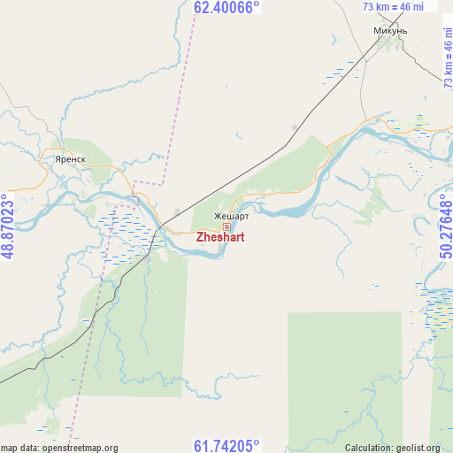
Zheshart GPS coordinates[2]
62° 4' 23.304" North, 49° 34' 24.06" East
| Map corner | latitude | longitude |
|---|---|---|
| Upper-left | 62.40066°, | 48.87023° |
| Center: | 62.07314°, | 49.57335° |
| Lower-right: | 61.74205°, | 50.27648° |
| Map W x H: | 73.2×73.2 km | = 45.5×45.5mi |
| max Lat: | 73.50819° ⇑5.1% North |
| Zheshart: | 62.07314° |
| min Lat: | ⇓94.9% South 41.28413° |
| min Long | Zheshart | max Long |
| -179.12198° | 49.57335° | 179.35046° |
| W 61.4%⇐ | ⇒38.6% E |
Elevation
Elevation of Zheshart is 102 m = 335 ft, and this is 100.6 m = 330 ft below average elevation for this country.
| Max E: |
2518 m = 8261 ft | 70.2% |
| Avg. | 202.6 m = 665 ft | |
| Zheshart | 102 m = 335 ft | |
Min E: |
-28 m = -92 ft | 29.8% |
See also: Russia elevation on elevation.city.
Geographical zone
Zheshart is located in North temperate zone (between Tropic of Cancer and the Arctic Circle). Distance of this North polar circle is 499.3 km =310.3 mi to North.| Distance of | km | miles | from Zheshart |
|---|---|---|---|
| North Pole | 3105.2 | 1929.5 | to North |
| Arctic Circle | 499.3 | 310.3 | to North |
| Tropic Cancer | 4296 | 2669.4 | to South |
| Equator | 6901.9 | 4288.6 | to South |


Nearby cities:
15 places around Zheshart: (largest is in red/bold)
• Aykino
27.5 km =17.1 mi,  52°
52°
• Ezhva
67 km =41.6 mi,  115°
115°
• Kharitonovo
132.4 km =82.3 mi,  235°
235°
• Kortkeros
109 km =67.7 mi,  105°
105°
• Mikun’
40.8 km =25.4 mi,  39°
39°
• Sedkyrkeshch
79 km =49.1 mi, 117°
• Syktyvkar
79.4 km =49.3 mi, 124°
• Urdoma
64.5 km =40.1 mi, 236°
• Ust’-Vym’
45.7 km =28.4 mi,  68°
68°
• Verkhnyaya Maksakovka
87.9 km =54.6 mi, 123°
• Vizinga
114.5 km =71.1 mi,  165°
165°
• Yarensk
27.2 km =16.9 mi,  292°
292°
• Yb
103.7 km =64.4 mi,  149°
149°
• Yemva
87.8 km =54.6 mi, 49°
• Zelenets
64.9 km =40.3 mi, 108°
Sources, notices
• [Note1] Compared only with cities in Russia existing in our database
• [Src1] Map data: © OpenStreetMap contributors (CC-BY-SA)
• [Src2] Other city data from geonames.org with taken over terms of usage.
• [Src3] Geographical zone / Annual Mean Temperature by Robert A. Rohde @ Wikipedia
