Aykino geodata
Aykino (Komi) is a populated place; located in Russia in Europe/Moscow (GMT+3) time zone. With population of 3,358 people, there are 3495 cities with bigger population in this country. Compared to other cities in Russia, 95.3% of cities are located further ↓South; 61.9% of cities are located further ←West and 79.6% of cities have higher elevation than Aykino. Note1


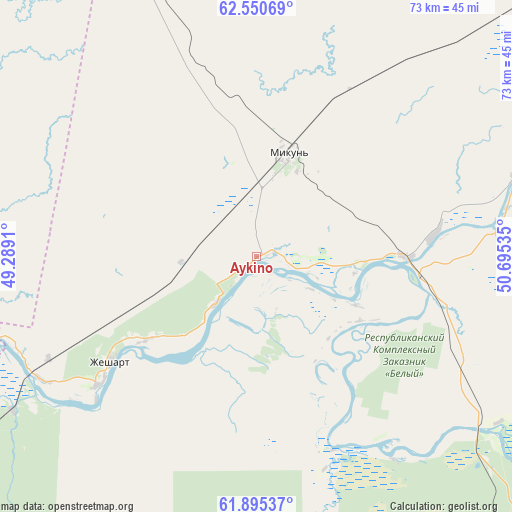
Aykino GPS coordinates[2]
62° 13' 29.316" North, 49° 59' 31.992" East
| Map corner | latitude | longitude |
|---|---|---|
| Upper-left | 62.55069°, | 49.2891° |
| Center: | 62.22481°, | 49.99222° |
| Lower-right: | 61.89537°, | 50.69535° |
| Map W x H: | 72.9×72.9 km | = 45.3×45.3mi |
| max Lat: | 73.50819° ⇑4.7% North |
| Aykino: | 62.22481° |
| min Lat: | ⇓95.3% South 41.28413° |
| min Long | Aykino | max Long |
| -179.12198° | 49.99222° | 179.35046° |
| W 61.9%⇐ | ⇒38.1% E |
Elevation
Elevation of Aykino is 72 m = 236 ft, and this is 130.6 m = 428 ft below average elevation for this country.
| Max E: |
2518 m = 8261 ft | 79.6% |
| Avg. | 202.6 m = 665 ft | |
| Aykino | 72 m = 236 ft | |
Min E: |
-28 m = -92 ft | 20.4% |
See also: Russia elevation on elevation.city.
Geographical zone
Aykino is located in North temperate zone (between Tropic of Cancer and the Arctic Circle). Distance of this North polar circle is 482.4 km =299.7 mi to North.| Distance of | km | miles | from Aykino |
|---|---|---|---|
| North Pole | 3088.3 | 1919 | to North |
| Arctic Circle | 482.4 | 299.7 | to North |
| Tropic Cancer | 4312.8 | 2679.8 | to South |
| Equator | 6918.8 | 4299.1 | to South |


Nearby cities:
15 places around Aykino: (largest is in red/bold)
• Ezhva
59.8 km =37.2 mi,  140°
140°
• Kortkeros
94.8 km =58.9 mi,  119°
119°
• Mikun’
15.1 km =9.4 mi,  16°
16°
• Sedkyrkeshch
71.5 km =44.4 mi, 137°
• Sindor
120.4 km =74.8 mi,  53°
53°
• Syktyvkar
75.8 km =47.1 mi,  145°
145°
• Urdoma
92 km =57.2 mi,  235°
235°
• Ust’-Vym’
20.7 km =12.9 mi,  89°
89°
• Verkhnyaya Maksakovka
83.1 km =51.6 mi, 142°
• Vizinga
128 km =79.5 mi,  177°
177°
• Yarensk
47.1 km =29.3 mi,  262°
262°
• Yb
110.3 km =68.5 mi,  163°
163°
• Yemva
60.4 km =37.5 mi, 47°
• Zelenets
54.6 km =33.9 mi,  133°
133°
• Zheshart
27.5 km =17.1 mi,  232°
232°
Sources, notices
• [Note1] Compared only with cities in Russia existing in our database
• [Src1] Map data: © OpenStreetMap contributors (CC-BY-SA)
• [Src2] Other city data from geonames.org with taken over terms of usage.
• [Src3] Geographical zone / Annual Mean Temperature by Robert A. Rohde @ Wikipedia
