Yekaterinovka geodata
Yekaterinovka (Saratovskaya Oblast) is a populated place; located in Russia in Europe/Saratov (GMT+4) time zone. With population of 6,435 people, there are 2146 cities with bigger population in this country. Compared to other cities in Russia, 68.9% of cities are located further ↑North; 51.9% of cities are located further →East and 76.3% of cities have lower elevation than Yekaterinovka. Note1


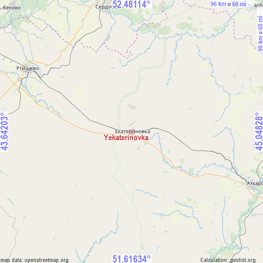
Yekaterinovka GPS coordinates[2]
52° 3' 2.988" North, 44° 20' 42.54" East
| Map corner | latitude | longitude |
|---|---|---|
| Upper-left | 52.48114°, | 43.64203° |
| Center: | 52.05083°, | 44.34515° |
| Lower-right: | 51.61634°, | 45.04828° |
| Map W x H: | 96.2×96.2 km | = 59.8×59.8mi |
| max Lat: | 73.50819° ⇑68.9% North |
| Yekaterinovka: | 52.05083° |
| min Lat: | ⇓31.1% South 41.28413° |
| min Long | Yekaterinovka | max Long |
| -179.12198° | 44.34515° | 179.35046° |
| W 48.1%⇐ | ⇒51.9% E |
Elevation
Elevation of Yekaterinovka is 222 m = 728 ft, and this is 19.4 m = 64 ft above average elevation for this country.
| Max E: |
2518 m = 8261 ft | 23.7% |
| Yekaterinovka | 222 m 728 ft | |
| Avg. | 202.6 m = 665 ft | |
Min E: |
-28 m = -92 ft | 76.3% |
See also: Russia elevation on elevation.city.
Geographical zone
Yekaterinovka is located in North temperate zone (between Tropic of Cancer and the Arctic Circle). Distance of this North polar circle is 1613.7 km =1002.7 mi to North.| Distance of | km | miles | from Yekaterinovka |
|---|---|---|---|
| North Pole | 4219.6 | 2621.9 | to North |
| Arctic Circle | 1613.7 | 1002.7 | to North |
| Tropic Cancer | 3181.6 | 1977 | to South |
| Equator | 5787.5 | 3596.2 | to South |


Nearby cities:
15 places around Yekaterinovka: (largest is in red/bold)
• Arkadak
59.5 km =37 mi,  257°
257°
• Atkarsk
49.6 km =30.8 mi,  113°
113°
• Bekovo
63.2 km =39.3 mi,  316°
316°
• Kalininsk
61.9 km =38.5 mi,  171°
171°
• Kolyshley
73.4 km =45.6 mi,  10°
10°
• Lysyye Gory
65.3 km =40.6 mi,  148°
148°
• Malaya Serdoba
61.9 km =38.5 mi,  41°
41°
• Petrovsk
76.8 km =47.7 mi,  68°
68°
• Repnoye
94.6 km =58.8 mi,  237°
237°
• Rtishchevo
44.6 km =27.7 mi,  301°
301°
• Serdobsk
46.2 km =28.7 mi,  349°
349°
• Svetlyy
97.7 km =60.7 mi,  115°
115°
• Tamala
92.2 km =57.3 mi,  306°
306°
• Tatishchevo
95.7 km =59.5 mi, 116°
• Turki
73.7 km =45.8 mi, 264°
Sources, notices
• [Note1] Compared only with cities in Russia existing in our database
• [Src1] Map data: © OpenStreetMap contributors (CC-BY-SA)
• [Src2] Other city data from geonames.org with taken over terms of usage.
• [Src3] Geographical zone / Annual Mean Temperature by Robert A. Rohde @ Wikipedia
