Lysyye Gory geodata
Lysyye Gory (Saratovskaya Oblast) is a populated place; located in Russia in Europe/Saratov (GMT+4) time zone. With population of 7,501 people, there are 1904 cities with bigger population in this country. Compared to other cities in Russia, 72.2% of cities are located further ↑North; 50.3% of cities are located further →East and 54.6% of cities have higher elevation than Lysyye Gory. Note1


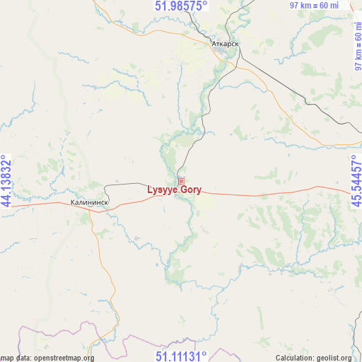
Lysyye Gory GPS coordinates[2]
51° 33' 2.268" North, 44° 50' 29.184" East
| Map corner | latitude | longitude |
|---|---|---|
| Upper-left | 51.98575°, | 44.13832° |
| Center: | 51.55063°, | 44.84144° |
| Lower-right: | 51.11131°, | 45.54457° |
| Map W x H: | 97.2×97.2 km | = 60.4×60.4mi |
| max Lat: | 73.50819° ⇑72.2% North |
| Lysyye Gory: | 51.55063° |
| min Lat: | ⇓27.8% South 41.28413° |
| min Long | Lysyye Gory | max Long |
| -179.12198° | 44.84144° | 179.35046° |
| W 49.7%⇐ | ⇒50.3% E |
Elevation
Elevation of Lysyye Gory is 135 m = 443 ft, and this is 67.6 m = 222 ft below average elevation for this country.
| Max E: |
2518 m = 8261 ft | 54.6% |
| Avg. | 202.6 m = 665 ft | |
| Lysyye Gory | 135 m = 443 ft | |
Min E: |
-28 m = -92 ft | 45.4% |
See also: Russia elevation on elevation.city.
Geographical zone
Lysyye Gory is located in North temperate zone (between Tropic of Cancer and the Arctic Circle). Distance of this North polar circle is 1669.3 km =1037.3 mi to North.| Distance of | km | miles | from Lysyye Gory |
|---|---|---|---|
| North Pole | 4275.2 | 2656.5 | to North |
| Arctic Circle | 1669.3 | 1037.3 | to North |
| Tropic Cancer | 3126 | 1942.4 | to South |
| Equator | 5731.9 | 3561.6 | to South |


Nearby cities:
15 places around Lysyye Gory: (largest is in red/bold)
• Atkarsk
37.5 km =23.3 mi,  17°
17°
• Engel’s
87.8 km =54.6 mi,  94°
94°
• Kalininsk
25.9 km =16.1 mi,  257°
257°
• Kamenskiy
86.6 km =53.8 mi,  148°
148°
• Krasnoarmeysk
83.5 km =51.9 mi,  134°
134°
• Krasnyy Oktyabr’
59.6 km =37 mi, 91°
• Medveditskiy
85.6 km =53.2 mi,  186°
186°
• Privolzhskiy
85 km =52.8 mi,  100°
100°
• Rudnya
85.9 km =53.4 mi, 193°
• Saratov
80.7 km =50.1 mi, 90°
• Sokolovyy
68.6 km =42.6 mi, 88°
• Svetlyy
56.2 km =34.9 mi,  75°
75°
• Tatishchevo
53.7 km =33.4 mi, 75°
• Yekaterinovka
65.3 km =40.6 mi,  328°
328°
• Zhirnovsk
63.1 km =39.2 mi,  184°
184°
Sources, notices
• [Note1] Compared only with cities in Russia existing in our database
• [Src1] Map data: © OpenStreetMap contributors (CC-BY-SA)
• [Src2] Other city data from geonames.org with taken over terms of usage.
• [Src3] Geographical zone / Annual Mean Temperature by Robert A. Rohde @ Wikipedia
