Yaroslavichi geodata
Yaroslavichi (Leningradskaya Oblast') is a seat of a third-order administrative division; located in Russia in Europe/Moscow (GMT+3) time zone. With population of 200 people, there are 4965 cities with bigger population in this country. Compared to other cities in Russia, 92.1% of cities are located further ↓South; 89.7% of cities are located further →East and 79% of cities have higher elevation than Yaroslavichi. Note1


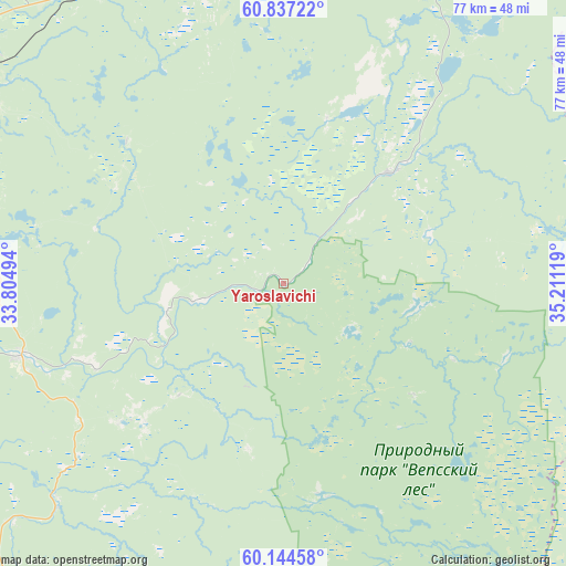
Yaroslavichi GPS coordinates[2]
60° 29' 33.9" North, 34° 30' 29.016" East
| Map corner | latitude | longitude |
|---|---|---|
| Upper-left | 60.83722°, | 33.80494° |
| Center: | 60.49275°, | 34.50806° |
| Lower-right: | 60.14458°, | 35.21119° |
| Map W x H: | 77×77 km | = 47.8×47.8mi |
| max Lat: | 73.50819° ⇑7.9% North |
| Yaroslavichi: | 60.49275° |
| min Lat: | ⇓92.1% South 41.28413° |
| min Long | Yaroslavichi | max Long |
| -179.12198° | 34.50806° | 179.35046° |
| W 10.3%⇐ | ⇒89.7% E |
Elevation
Elevation of Yaroslavichi is 74 m = 243 ft, and this is 128.6 m = 422 ft below average elevation for this country.
| Max E: |
2518 m = 8261 ft | 79% |
| Avg. | 202.6 m = 665 ft | |
| Yaroslavichi | 74 m = 243 ft | |
Min E: |
-28 m = -92 ft | 21% |
See also: Russia elevation on elevation.city.
Geographical zone
Yaroslavichi is located in North temperate zone (between Tropic of Cancer and the Arctic Circle). Distance of this North polar circle is 675 km =419.4 mi to North.| Distance of | km | miles | from Yaroslavichi |
|---|---|---|---|
| North Pole | 3280.9 | 2038.7 | to North |
| Arctic Circle | 675 | 419.4 | to North |
| Tropic Cancer | 4120.2 | 2560.2 | to South |
| Equator | 6726.2 | 4179.5 | to South |


Nearby cities:
15 places around Yaroslavichi: (largest is in red/bold)
• Khvalovo
115 km =71.5 mi,  238°
238°
• Kvartsitnyy
114.7 km =71.3 mi,  14°
14°
• Lodeynoye Pole
58.2 km =36.2 mi,  296°
296°
• Olonets
99.9 km =62.1 mi, 303°
• Pasha
81.1 km =50.4 mi,  262°
262°
• Pikalëvo
110 km =68.4 mi,  189°
189°
• Podporozh’ye
50 km =31.1 mi,  338°
338°
• Sheltozero
107.7 km =66.9 mi,  25°
25°
• Svir'stroy
55 km =34.2 mi,  308°
308°
• Syas’stroy
113.9 km =70.8 mi,  249°
249°
• Tikhvin
108.8 km =67.6 mi,  209°
209°
• Vazhiny
58.7 km =36.5 mi,  333°
333°
• Vinnitsy
20.9 km =13 mi,  43°
43°
• Voznesen’ye
78.1 km =48.5 mi, 42°
• Yefimovskiy
111.2 km =69.1 mi,  175°
175°
Sources, notices
• [Note1] Compared only with cities in Russia existing in our database
• [Src1] Map data: © OpenStreetMap contributors (CC-BY-SA)
• [Src2] Other city data from geonames.org with taken over terms of usage.
• [Src3] Geographical zone / Annual Mean Temperature by Robert A. Rohde @ Wikipedia
