Syas’stroy geodata
Syas’stroy (Leningradskaya Oblast') is a populated place; located in Russia in Europe/Moscow (GMT+3) time zone. With population of 13,300 people, there are 1185 cities with bigger population in this country. Compared to other cities in Russia, 91.1% of cities are located further ↓South; 92.6% of cities are located further →East and 96.4% of cities have higher elevation than Syas’stroy. Note1


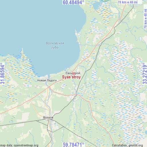
Syas’stroy GPS coordinates[2]
60° 8' 12.084" North, 32° 34' 8.616" East
| Map corner | latitude | longitude |
|---|---|---|
| Upper-left | 60.48494°, | 31.86594° |
| Center: | 60.13669°, | 32.56906° |
| Lower-right: | 59.78471°, | 33.27219° |
| Map W x H: | 77.9×77.9 km | = 48.4×48.4mi |
| max Lat: | 73.50819° ⇑8.9% North |
| Syas’stroy: | 60.13669° |
| min Lat: | ⇓91.1% South 41.28413° |
| min Long | Syas’stroy | max Long |
| -179.12198° | 32.56906° | 179.35046° |
| W 7.4%⇐ | ⇒92.6% E |
Elevation
Elevation of Syas’stroy is 9 m = 30 ft, and this is 193.6 m = 635 ft below average elevation for this country.
| Max E: |
2518 m = 8261 ft | 96.4% |
| Avg. | 202.6 m = 665 ft | |
| Syas’stroy | 9 m = 30 ft | |
Min E: |
-28 m = -92 ft | 3.6% |
See also: Russia elevation on elevation.city.
Geographical zone
Syas’stroy is located in North temperate zone (between Tropic of Cancer and the Arctic Circle). Distance of this North polar circle is 714.6 km =444 mi to North.| Distance of | km | miles | from Syas’stroy |
|---|---|---|---|
| North Pole | 3320.5 | 2063.3 | to North |
| Arctic Circle | 714.6 | 444 | to North |
| Tropic Cancer | 4080.7 | 2535.6 | to South |
| Equator | 6686.6 | 4154.9 | to South |


Nearby cities:
15 places around Syas’stroy: (largest is in red/bold)
• Borisova Griva
88.3 km =54.9 mi,  266°
266°
• Imeni Morozova
86.9 km =54 mi,  258°
258°
• Issad
14.7 km =9.1 mi,  238°
238°
• Khvalovo
23 km =14.3 mi,  156°
156°
• Kirishi
82.6 km =51.3 mi,  201°
201°
• Kolchanovo
13.4 km =8.3 mi,  175°
175°
• Lodeynoye Pole
84.9 km =52.8 mi,  39°
39°
• Novaya Ladoga
15.3 km =9.5 mi, 255°
• Pasha
38.9 km =24.2 mi, 42°
• Priladozhskiy
68.3 km =42.4 mi, 242°
• Shlissel’burg
87.6 km =54.4 mi, 256°
• Sinyavino
87 km =54.1 mi,  252°
252°
• Staraya Ladoga
21.6 km =13.4 mi,  224°
224°
• Tikhvin
76.5 km =47.5 mi,  135°
135°
• Volkhov
26.7 km =16.6 mi,  208°
208°
Sources, notices
• [Note1] Compared only with cities in Russia existing in our database
• [Src1] Map data: © OpenStreetMap contributors (CC-BY-SA)
• [Src2] Other city data from geonames.org with taken over terms of usage.
• [Src3] Geographical zone / Annual Mean Temperature by Robert A. Rohde @ Wikipedia
