Veshkelitsa geodata
Veshkelitsa (Karelia) is a populated place; located in Russia in Europe/Moscow (GMT+3) time zone. With population of 525 people, there are 4948 cities with bigger population in this country. Compared to other cities in Russia, 94.7% of cities are located further ↓South; 92.2% of cities are located further →East and 56.8% of cities have lower elevation than Veshkelitsa. Note1


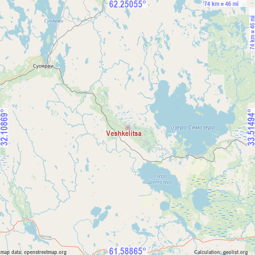
Veshkelitsa GPS coordinates[2]
61° 55' 17.004" North, 32° 48' 42.516" East
| Map corner | latitude | longitude |
|---|---|---|
| Upper-left | 62.25055°, | 32.10869° |
| Center: | 61.92139°, | 32.81181° |
| Lower-right: | 61.58865°, | 33.51494° |
| Map W x H: | 73.6×73.6 km | = 45.7×45.7mi |
| max Lat: | 73.50819° ⇑5.3% North |
| Veshkelitsa: | 61.92139° |
| min Lat: | ⇓94.7% South 41.28413° |
| min Long | Veshkelitsa | max Long |
| -179.12198° | 32.81181° | 179.35046° |
| W 7.8%⇐ | ⇒92.2% E |
Elevation
Elevation of Veshkelitsa is 160 m = 525 ft, and this is 42.6 m = 140 ft below average elevation for this country.
| Max E: |
2518 m = 8261 ft | 43.2% |
| Avg. | 202.6 m = 665 ft | |
| Veshkelitsa | 160 m = 525 ft | |
Min E: |
-28 m = -92 ft | 56.8% |
See also: Russia elevation on elevation.city.
Geographical zone
Veshkelitsa is located in North temperate zone (between Tropic of Cancer and the Arctic Circle). Distance of this North polar circle is 516.2 km =320.8 mi to North.| Distance of | km | miles | from Veshkelitsa |
|---|---|---|---|
| North Pole | 3122 | 1939.9 | to North |
| Arctic Circle | 516.2 | 320.8 | to North |
| Tropic Cancer | 4279.1 | 2658.9 | to South |
| Equator | 6885 | 4278.1 | to South |


Nearby cities:
15 places around Veshkelitsa: (largest is in red/bold)
• Essoyla
18.6 km =11.6 mi,  107°
107°
• Girvas
76.8 km =47.7 mi,  36°
36°
• Kondopoga
81.9 km =50.9 mi,  67°
67°
• Lyaskelya
96.4 km =59.9 mi,  259°
259°
• Matrosy
54.8 km =34.1 mi, 106°
• Petrozavodsk
81.9 km =50.9 mi,  100°
100°
• Pitkyaranta
80.1 km =49.8 mi,  241°
241°
• Porosozero
88.8 km =55.2 mi,  357°
357°
• Pryazha
49.6 km =30.8 mi,  120°
120°
• Salmi
79.6 km =49.5 mi,  219°
219°
• Shuya
74.4 km =46.2 mi,  87°
87°
• Suoyarvi
30.1 km =18.7 mi,  306°
306°
• Syapsya
30.1 km =18.7 mi, 89°
• Yanishpole
78.9 km =49 mi, 74°
• Yanis’yarvi
97.6 km =60.6 mi,  268°
268°
Sources, notices
• [Note1] Compared only with cities in Russia existing in our database
• [Src1] Map data: © OpenStreetMap contributors (CC-BY-SA)
• [Src2] Other city data from geonames.org with taken over terms of usage.
• [Src3] Geographical zone / Annual Mean Temperature by Robert A. Rohde @ Wikipedia
