Suoyarvi geodata
Suoyarvi (Karelia) is a populated place; located in Russia in Europe/Moscow (GMT+3) time zone. With population of 10,833 people, there are 1395 cities with bigger population in this country. Compared to other cities in Russia, 94.9% of cities are located further ↓South; 92.9% of cities are located further →East and 57.2% of cities have lower elevation than Suoyarvi. Note1


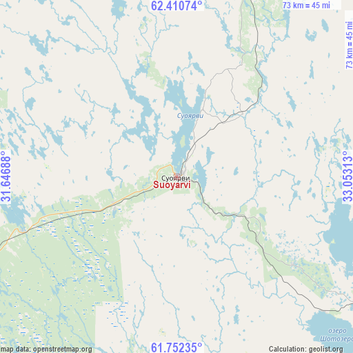
Suoyarvi GPS coordinates[2]
62° 4' 59.988" North, 32° 21' 0" East
| Map corner | latitude | longitude |
|---|---|---|
| Upper-left | 62.41074°, | 31.64688° |
| Center: | 62.08333°, | 32.35° |
| Lower-right: | 61.75235°, | 33.05313° |
| Map W x H: | 73.2×73.2 km | = 45.5×45.5mi |
| max Lat: | 73.50819° ⇑5.1% North |
| Suoyarvi: | 62.08333° |
| min Lat: | ⇓94.9% South 41.28413° |
| min Long | Suoyarvi | max Long |
| -179.12198° | 32.35° | 179.35046° |
| W 7.1%⇐ | ⇒92.9% E |
Elevation
Elevation of Suoyarvi is 161 m = 528 ft, and this is 41.6 m = 136 ft below average elevation for this country.
| Max E: |
2518 m = 8261 ft | 42.8% |
| Avg. | 202.6 m = 665 ft | |
| Suoyarvi | 161 m = 528 ft | |
Min E: |
-28 m = -92 ft | 57.2% |
See also: Russia elevation on elevation.city.
Geographical zone
Suoyarvi is located in North temperate zone (between Tropic of Cancer and the Arctic Circle). Distance of this North polar circle is 498.2 km =309.6 mi to North.| Distance of | km | miles | from Suoyarvi |
|---|---|---|---|
| North Pole | 3104 | 1928.7 | to North |
| Arctic Circle | 498.2 | 309.6 | to North |
| Tropic Cancer | 4297.1 | 2670.1 | to South |
| Equator | 6903 | 4289.3 | to South |


Nearby cities:
15 places around Suoyarvi: (largest is in red/bold)
• Essoyla
48 km =29.8 mi,  119°
119°
• Girvas
81.9 km =50.9 mi,  57°
57°
• Kharlu
79.7 km =49.5 mi,  246°
246°
• Lyaskelya
78.8 km =49 mi,  243°
243°
• Matrosy
83.6 km =51.9 mi,  113°
113°
• Pitkyaranta
72.8 km =45.2 mi,  218°
218°
• Porosozero
73.3 km =45.5 mi,  15°
15°
• Pryazha
79.5 km =49.4 mi, 123°
• Ruskeala
93.7 km =58.2 mi,  259°
259°
• Salmi
83.6 km =51.9 mi,  198°
198°
• Sortavala
95.3 km =59.2 mi, 244°
• Syapsya
57 km =35.4 mi, 108°
• Veshkelitsa
30.1 km =18.7 mi,  126°
126°
• Vyartsilya
86.7 km =53.9 mi,  276°
276°
• Yanis’yarvi
76.2 km =47.3 mi, 253°
Sources, notices
• [Note1] Compared only with cities in Russia existing in our database
• [Src1] Map data: © OpenStreetMap contributors (CC-BY-SA)
• [Src2] Other city data from geonames.org with taken over terms of usage.
• [Src3] Geographical zone / Annual Mean Temperature by Robert A. Rohde @ Wikipedia
