Vladimirskaya geodata
Vladimirskaya (Krasnodarskiy) is a populated place; located in Russia in Europe/Moscow (GMT+3) time zone. With population of 7,278 people, there are 1937 cities with bigger population in this country. Compared to other cities in Russia, 89.4% of cities are located further ↑North; 63.9% of cities are located further →East and 84.8% of cities have lower elevation than Vladimirskaya. Note1


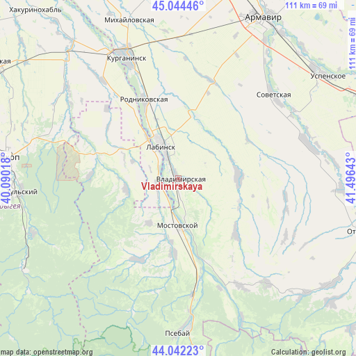
Vladimirskaya GPS coordinates[2]
44° 32' 43.8" North, 40° 47' 35.88" East
| Map corner | latitude | longitude |
|---|---|---|
| Upper-left | 45.04446°, | 40.09018° |
| Center: | 44.5455°, | 40.7933° |
| Lower-right: | 44.04223°, | 41.49643° |
| Map W x H: | 111.4×111.4 km | = 69.2×69.2mi |
| max Lat: | 73.50819° ⇑89.4% North |
| Vladimirskaya: | 44.5455° |
| min Lat: | ⇓10.6% South 41.28413° |
| min Long | Vladimirskaya | max Long |
| -179.12198° | 40.7933° | 179.35046° |
| W 36.1%⇐ | ⇒63.9% E |
Elevation
Elevation of Vladimirskaya is 316 m = 1037 ft, and this is 113.4 m = 372 ft above average elevation for this country.
| Max E: |
2518 m = 8261 ft | 15.2% |
| Vladimirskaya | 316 m 1037 ft | |
| Avg. | 202.6 m = 665 ft | |
Min E: |
-28 m = -92 ft | 84.8% |
See also: Russia elevation on elevation.city.
Geographical zone
Vladimirskaya is located in North temperate zone (between Tropic of Cancer and the Arctic Circle). Distance of this Northern Tropic circle is 2347.1 km =1458.4 mi to South.| Distance of | km | miles | from Vladimirskaya |
|---|---|---|---|
| North Pole | 5054.1 | 3140.5 | to North |
| Arctic Circle | 2448.2 | 1521.2 | to North |
| Tropic Cancer | 2347.1 | 1458.4 | to South |
| Equator | 4953 | 3077.7 | to South |


Nearby cities:
15 places around Vladimirskaya: (largest is in red/bold)
• Besleneyevskaya
35.4 km =22 mi,  188°
188°
• Chamlykskaya
20.1 km =12.5 mi,  19°
19°
• Gubskaya
28.4 km =17.6 mi,  206°
206°
• Khodz’
7.4 km =4.6 mi,  237°
237°
• Konstantinovskaya
32.6 km =20.3 mi,  350°
350°
• Labinsk
10.9 km =6.8 mi,  335°
335°
• Mostovskoy
14.8 km =9.2 mi,  179°
179°
• Natyrbovo
24.4 km =15.2 mi,  327°
327°
• Novoalekseyevskaya
32.4 km =20.1 mi, 20°
• Perepravnaya
23.2 km =14.4 mi, 181°
• Rodnikovskaya
26.4 km =16.4 mi, 337°
• Shedok
36.7 km =22.8 mi,  173°
173°
• Upornaya
24.8 km =15.4 mi,  133°
133°
• Voznesenskaya
18.9 km =11.7 mi,  87°
87°
• Yaroslavskaya
27.1 km =16.8 mi,  285°
285°
Sources, notices
• [Note1] Compared only with cities in Russia existing in our database
• [Src1] Map data: © OpenStreetMap contributors (CC-BY-SA)
• [Src2] Other city data from geonames.org with taken over terms of usage.
• [Src3] Geographical zone / Annual Mean Temperature by Robert A. Rohde @ Wikipedia
