Natyrbovo geodata
Natyrbovo (Adygeya Republic) is a populated place; located in Russia in Europe/Moscow (GMT+3) time zone. With population of 3,377 people, there are 3476 cities with bigger population in this country. Compared to other cities in Russia, 88.7% of cities are located further ↑North; 64.5% of cities are located further →East and 75.7% of cities have lower elevation than Natyrbovo. Note1


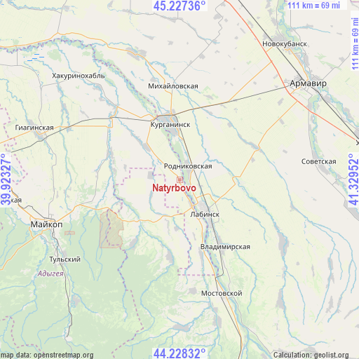
Natyrbovo GPS coordinates[2]
44° 43' 48" North, 40° 37' 35.004" East
| Map corner | latitude | longitude |
|---|---|---|
| Upper-left | 45.22736°, | 39.92327° |
| Center: | 44.73°, | 40.62639° |
| Lower-right: | 44.22832°, | 41.32952° |
| Map W x H: | 111.1×111.1 km | = 69×69mi |
| max Lat: | 73.50819° ⇑88.7% North |
| Natyrbovo: | 44.73° |
| min Lat: | ⇓11.3% South 41.28413° |
| min Long | Natyrbovo | max Long |
| -179.12198° | 40.62639° | 179.35046° |
| W 35.5%⇐ | ⇒64.5% E |
Elevation
Elevation of Natyrbovo is 220 m = 722 ft, and this is 17.4 m = 57 ft above average elevation for this country.
| Max E: |
2518 m = 8261 ft | 24.3% |
| Natyrbovo | 220 m 722 ft | |
| Avg. | 202.6 m = 665 ft | |
Min E: |
-28 m = -92 ft | 75.7% |
See also: Russia elevation on elevation.city.
Geographical zone
Natyrbovo is located in North temperate zone (between Tropic of Cancer and the Arctic Circle). Distance of this Northern Tropic circle is 2367.6 km =1471.2 mi to South.| Distance of | km | miles | from Natyrbovo |
|---|---|---|---|
| North Pole | 5033.6 | 3127.7 | to North |
| Arctic Circle | 2427.7 | 1508.5 | to North |
| Tropic Cancer | 2367.6 | 1471.2 | to South |
| Equator | 4973.5 | 3090.4 | to South |


Nearby cities:
15 places around Natyrbovo: (largest is in red/bold)
• Blechepsin
14.1 km =8.8 mi,  315°
315°
• Chamlykskaya
20 km =12.4 mi,  94°
94°
• Dondukovskaya
26.8 km =16.7 mi,  309°
309°
• Khodz’
25.4 km =15.8 mi,  164°
164°
• Konstantinovskaya
14.1 km =8.8 mi,  34°
34°
• Koshekhabl’
20.7 km =12.9 mi,  334°
334°
• Kurganinsk
16.8 km =10.4 mi,  352°
352°
• Kuzhorskaya
25.7 km =16 mi,  256°
256°
• Labinsk
13.7 km =8.5 mi,  140°
140°
• Mikhaylovskaya
29.5 km =18.3 mi,  355°
355°
• Novoalekseyevskaya
26.2 km =16.3 mi,  67°
67°
• Rodnikovskaya
4.9 km =3 mi,  38°
38°
• Vladimirskaya
24.4 km =15.2 mi,  147°
147°
• Yaroslavskaya
18.5 km =11.5 mi,  224°
224°
• Yuzhnyy
32.6 km =20.3 mi,  338°
338°
Sources, notices
• [Note1] Compared only with cities in Russia existing in our database
• [Src1] Map data: © OpenStreetMap contributors (CC-BY-SA)
• [Src2] Other city data from geonames.org with taken over terms of usage.
• [Src3] Geographical zone / Annual Mean Temperature by Robert A. Rohde @ Wikipedia
