Khodz’ geodata
Khodz’ (Adygeya Republic) is a populated place; located in Russia in Europe/Moscow (GMT+3) time zone. With population of 3,028 people, there are 3755 cities with bigger population in this country. Compared to other cities in Russia, 89.4% of cities are located further ↑North; 64.1% of cities are located further →East and 85.1% of cities have lower elevation than Khodz’. Note1


Khodz’ GPS coordinates[2]
44° 30' 36.72" North, 40° 42' 51.12" East
| Map corner | latitude | longitude |
|---|---|---|
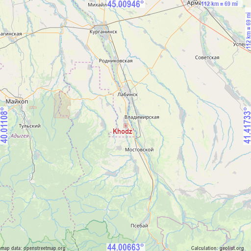
| Upper-left | 45.00946°, | 40.01108° |
| Center: | 44.5102°, | 40.7142° |
| Lower-right: | 44.00663°, | 41.41733° |
| Map W x H: | 111.5×111.5 km | = 69.3×69.3mi |
| max Lat: | 73.50819° ⇑89.4% North |
| Khodz’: | 44.5102° |
| min Lat: | ⇓10.6% South 41.28413° |
| min Long | Khodz’ | max Long |
| -179.12198° | 40.7142° | 179.35046° |
| W 35.9%⇐ | ⇒64.1% E |
Elevation
Elevation of Khodz’ is 321 m = 1053 ft, and this is 118.4 m = 388 ft above average elevation for this country.
| Max E: |
2518 m = 8261 ft | 14.9% |
| Khodz’ | 321 m 1053 ft | |
| Avg. | 202.6 m = 665 ft | |
Min E: |
-28 m = -92 ft | 85.1% |
See also: Russia elevation on elevation.city.
Geographical zone
Khodz’ is located in North temperate zone (between Tropic of Cancer and the Arctic Circle). Distance of this Northern Tropic circle is 2343.2 km =1456 mi to South.| Distance of | km | miles | from Khodz’ |
|---|---|---|---|
| North Pole | 5058 | 3142.9 | to North |
| Arctic Circle | 2452.1 | 1523.7 | to North |
| Tropic Cancer | 2343.2 | 1456 | to South |
| Equator | 4949.1 | 3075.2 | to South |


Nearby cities:
15 places around Khodz’: (largest is in red/bold)
• Besleneyevskaya
31.1 km =19.3 mi,  178°
178°
• Chamlykskaya
26.3 km =16.3 mi,  29°
29°
• Gubskaya
22.4 km =13.9 mi,  196°
196°
• Konstantinovskaya
36.2 km =22.5 mi,  1°
1°
• Kuzhorskaya
36.9 km =22.9 mi,  299°
299°
• Labinsk
13.9 km =8.6 mi,  6°
6°
• Mostovskoy
12.6 km =7.8 mi,  149°
149°
• Natyrbovo
25.4 km =15.8 mi,  344°
344°
• Perepravnaya
20.1 km =12.5 mi,  163°
163°
• Rodnikovskaya
28.5 km =17.7 mi,  352°
352°
• Shedok
34.2 km =21.3 mi, 161°
• Upornaya
27.6 km =17.1 mi,  118°
118°
• Vladimirskaya
7.4 km =4.6 mi,  57°
57°
• Voznesenskaya
25.6 km =15.9 mi,  79°
79°
• Yaroslavskaya
22.7 km =14.1 mi, 299°
Sources, notices
• [Note1] Compared only with cities in Russia existing in our database
• [Src1] Map data: © OpenStreetMap contributors (CC-BY-SA)
• [Src2] Other city data from geonames.org with taken over terms of usage.
• [Src3] Geographical zone / Annual Mean Temperature by Robert A. Rohde @ Wikipedia
