Krasnyye Chetai geodata
Krasnyye Chetai (Chuvashia) is a populated place; located in Russia in Europe/Moscow (GMT+3) time zone. With population of 2,954 people, there are 3804 cities with bigger population in this country. Compared to other cities in Russia, 61.4% of cities are located further ↓South; 53.2% of cities are located further ←West and 60% of cities have higher elevation than Krasnyye Chetai. Note1


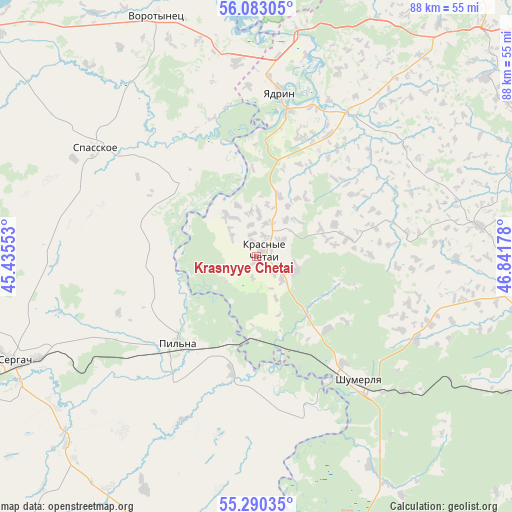
Krasnyye Chetai GPS coordinates[2]
55° 41' 19.356" North, 46° 8' 19.14" East
| Map corner | latitude | longitude |
|---|---|---|
| Upper-left | 56.08305°, | 45.43553° |
| Center: | 55.68871°, | 46.13865° |
| Lower-right: | 55.29035°, | 46.84178° |
| Map W x H: | 88.1×88.1 km | = 54.7×54.7mi |
| max Lat: | 73.50819° ⇑38.6% North |
| Krasnyye Chetai: | 55.68871° |
| min Lat: | ⇓61.4% South 41.28413° |
| min Long | Krasnyye Chetai | max Long |
| -179.12198° | 46.13865° | 179.35046° |
| W 53.2%⇐ | ⇒46.8% E |
Elevation
Elevation of Krasnyye Chetai is 124 m = 407 ft, and this is 78.6 m = 258 ft below average elevation for this country.
| Max E: |
2518 m = 8261 ft | 60% |
| Avg. | 202.6 m = 665 ft | |
| Krasnyye Chetai | 124 m = 407 ft | |
Min E: |
-28 m = -92 ft | 40% |
See also: Russia elevation on elevation.city.
Geographical zone
Krasnyye Chetai is located in North temperate zone (between Tropic of Cancer and the Arctic Circle). Distance of this North polar circle is 1209.2 km =751.4 mi to North.| Distance of | km | miles | from Krasnyye Chetai |
|---|---|---|---|
| North Pole | 3815.1 | 2370.6 | to North |
| Arctic Circle | 1209.2 | 751.4 | to North |
| Tropic Cancer | 3586.1 | 2228.3 | to South |
| Equator | 6192 | 3847.5 | to South |


Nearby cities:
15 places around Krasnyye Chetai: (largest is in red/bold)
• Alikovo
39 km =24.2 mi,  81°
81°
• Krasnaya Gorka
33.6 km =20.9 mi,  183°
183°
• Morgaushi
50.1 km =31.1 mi,  52°
52°
• Pil’na
20.2 km =12.6 mi,  222°
222°
• Poretskoye
55.9 km =34.7 mi,  167°
167°
• Sechenovo
53.9 km =33.5 mi,  196°
196°
• Sergach
45.7 km =28.4 mi,  247°
247°
• Shumerlya
27.1 km =16.8 mi,  140°
140°
• Spasskoye
33.6 km =20.9 mi,  304°
304°
• Urazovka
45.7 km =28.4 mi,  225°
225°
• Vasil’sursk
49.8 km =30.9 mi,  351°
351°
• Vilovatovo
61 km =37.9 mi,  28°
28°
• Vorotynets
44.7 km =27.8 mi,  337°
337°
• Vurnary
56.4 km =35 mi,  113°
113°
• Yadrin
28.3 km =17.6 mi,  8°
8°
Sources, notices
• [Note1] Compared only with cities in Russia existing in our database
• [Src1] Map data: © OpenStreetMap contributors (CC-BY-SA)
• [Src2] Other city data from geonames.org with taken over terms of usage.
• [Src3] Geographical zone / Annual Mean Temperature by Robert A. Rohde @ Wikipedia
