Sergach geodata
Sergach (Nizhny Novgorod Oblast) is a populated place; located in Russia in Europe/Moscow (GMT+3) time zone. With population of 22,361 people, there are 806 cities with bigger population in this country. Compared to other cities in Russia, 58.5% of cities are located further ↓South; 51.4% of cities are located further ←West and 55.6% of cities have higher elevation than Sergach. Note1


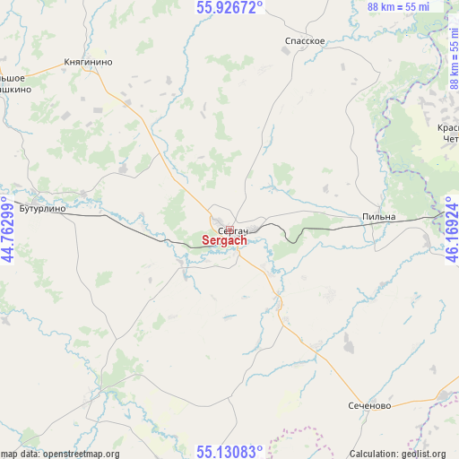
Sergach GPS coordinates[2]
55° 31' 50.844" North, 45° 27' 57.996" East
| Map corner | latitude | longitude |
|---|---|---|
| Upper-left | 55.92672°, | 44.76299° |
| Center: | 55.53079°, | 45.46611° |
| Lower-right: | 55.13083°, | 46.16924° |
| Map W x H: | 88.5×88.5 km | = 55×55mi |
| max Lat: | 73.50819° ⇑41.5% North |
| Sergach: | 55.53079° |
| min Lat: | ⇓58.5% South 41.28413° |
| min Long | Sergach | max Long |
| -179.12198° | 45.46611° | 179.35046° |
| W 51.4%⇐ | ⇒48.6% E |
Elevation
Elevation of Sergach is 133 m = 436 ft, and this is 69.6 m = 228 ft below average elevation for this country.
| Max E: |
2518 m = 8261 ft | 55.6% |
| Avg. | 202.6 m = 665 ft | |
| Sergach | 133 m = 436 ft | |
Min E: |
-28 m = -92 ft | 44.4% |
See also: Russia elevation on elevation.city.
Geographical zone
Sergach is located in North temperate zone (between Tropic of Cancer and the Arctic Circle). Distance of this North polar circle is 1226.7 km =762.2 mi to North.| Distance of | km | miles | from Sergach |
|---|---|---|---|
| North Pole | 3832.6 | 2381.5 | to North |
| Arctic Circle | 1226.7 | 762.2 | to North |
| Tropic Cancer | 3568.5 | 2217.4 | to South |
| Equator | 6174.4 | 3836.6 | to South |


Nearby cities:
15 places around Sergach: (largest is in red/bold)
• Bol’shoye Boldino
59.2 km =36.8 mi,  189°
189°
• Bol’shoye Murashkino
51.6 km =32.1 mi,  302°
302°
• Buturlino
36 km =22.4 mi,  276°
276°
• Gagino
43.1 km =26.8 mi,  219°
219°
• Knyaginino
42.2 km =26.2 mi,  320°
320°
• Krasnaya Gorka
43.6 km =27.1 mi,  111°
111°
• Krasnyye Chetai
45.7 km =28.4 mi,  67°
67°
• Lyskovo
61.8 km =38.4 mi,  334°
334°
• Perevoz
58.4 km =36.3 mi, 277°
• Pil’na
28.8 km =17.9 mi,  84°
84°
• Sechenovo
43.4 km =27 mi,  141°
141°
• Shumerlya
59.7 km =37.1 mi,  93°
93°
• Spasskoye
39.4 km =24.5 mi,  21°
21°
• Urazovka
17.3 km =10.7 mi,  146°
146°
• Vorotynets
63.9 km =39.7 mi, 22°
Sources, notices
• [Note1] Compared only with cities in Russia existing in our database
• [Src1] Map data: © OpenStreetMap contributors (CC-BY-SA)
• [Src2] Other city data from geonames.org with taken over terms of usage.
• [Src3] Geographical zone / Annual Mean Temperature by Robert A. Rohde @ Wikipedia
