Pryazha geodata
Pryazha (Karelia) is a populated place; located in Russia in Europe/Moscow (GMT+3) time zone. With population of 4,156 people, there are 3027 cities with bigger population in this country. Compared to other cities in Russia, 94.2% of cities are located further ↓South; 91.1% of cities are located further →East and 79.2% of cities have higher elevation than Pryazha. Note1


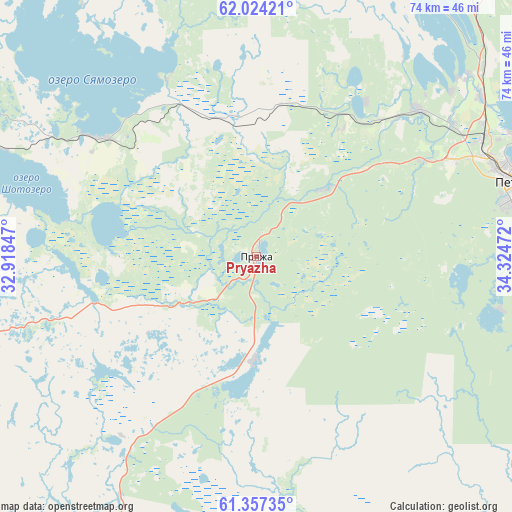
Pryazha GPS coordinates[2]
61° 41' 33.288" North, 33° 37' 17.724" East
| Map corner | latitude | longitude |
|---|---|---|
| Upper-left | 62.02421°, | 32.91847° |
| Center: | 61.69258°, | 33.62159° |
| Lower-right: | 61.35735°, | 34.32472° |
| Map W x H: | 74.1×74.1 km | = 46×46mi |
| max Lat: | 73.50819° ⇑5.8% North |
| Pryazha: | 61.69258° |
| min Lat: | ⇓94.2% South 41.28413° |
| min Long | Pryazha | max Long |
| -179.12198° | 33.62159° | 179.35046° |
| W 8.9%⇐ | ⇒91.1% E |
Elevation
Elevation of Pryazha is 73 m = 240 ft, and this is 129.6 m = 425 ft below average elevation for this country.
| Max E: |
2518 m = 8261 ft | 79.2% |
| Avg. | 202.6 m = 665 ft | |
| Pryazha | 73 m = 240 ft | |
Min E: |
-28 m = -92 ft | 20.8% |
See also: Russia elevation on elevation.city.
Geographical zone
Pryazha is located in North temperate zone (between Tropic of Cancer and the Arctic Circle). Distance of this North polar circle is 541.6 km =336.5 mi to North.| Distance of | km | miles | from Pryazha |
|---|---|---|---|
| North Pole | 3147.5 | 1955.8 | to North |
| Arctic Circle | 541.6 | 336.5 | to North |
| Tropic Cancer | 4253.7 | 2643.1 | to South |
| Equator | 6859.6 | 4262.4 | to South |


Nearby cities:
15 places around Pryazha: (largest is in red/bold)
• Essoyla
31.7 km =19.7 mi,  308°
308°
• Girvas
87.6 km =54.4 mi,  2°
2°
• Kondopoga
66.1 km =41.1 mi,  30°
30°
• Kvartsitnyy
77.7 km =48.3 mi,  106°
106°
• Matrosy
14 km =8.7 mi,  45°
45°
• Olonets
86 km =53.4 mi,  203°
203°
• Petrozavodsk
39.5 km =24.5 mi,  74°
74°
• Podporozh’ye
91.7 km =57 mi,  161°
161°
• Sheltozero
99.3 km =61.7 mi, 111°
• Shuya
43.2 km =26.8 mi, 47°
• Suoyarvi
79.5 km =49.4 mi,  303°
303°
• Syapsya
28.4 km =17.6 mi,  334°
334°
• Vazhiny
83.7 km =52 mi,  165°
165°
• Veshkelitsa
49.6 km =30.8 mi, 300°
• Yanishpole
57.6 km =35.8 mi,  36°
36°
Sources, notices
• [Note1] Compared only with cities in Russia existing in our database
• [Src1] Map data: © OpenStreetMap contributors (CC-BY-SA)
• [Src2] Other city data from geonames.org with taken over terms of usage.
• [Src3] Geographical zone / Annual Mean Temperature by Robert A. Rohde @ Wikipedia
