Petrozavodsk geodata
Petrozavodsk (Karelia) is a seat of a first-order administrative division; located in Russia in Europe/Moscow (GMT+3) time zone. With population of 265,025 people, there are 74 cities with bigger population in this country. Compared to other cities in Russia, 94.4% of cities are located further ↓South; 89.9% of cities are located further →East and 79.2% of cities have higher elevation than Petrozavodsk. Note1


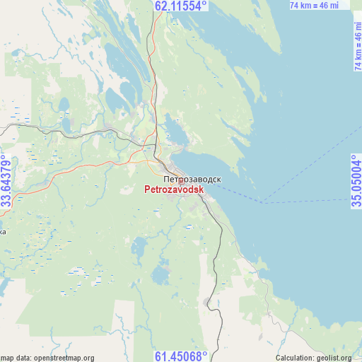
Petrozavodsk GPS coordinates[2]
61° 47' 5.676" North, 34° 20' 48.876" East
| Map corner | latitude | longitude |
|---|---|---|
| Upper-left | 62.11554°, | 33.64379° |
| Center: | 61.78491°, | 34.34691° |
| Lower-right: | 61.45068°, | 35.05004° |
| Map W x H: | 73.9×73.9 km | = 45.9×45.9mi |
| max Lat: | 73.50819° ⇑5.6% North |
| Petrozavodsk: | 61.78491° |
| min Lat: | ⇓94.4% South 41.28413° |
| min Long | Petrozavodsk | max Long |
| -179.12198° | 34.34691° | 179.35046° |
| W 10.1%⇐ | ⇒89.9% E |
Elevation
Elevation of Petrozavodsk is 73 m = 240 ft, and this is 129.6 m = 425 ft below average elevation for this country.
| Max E: |
2518 m = 8261 ft | 79.2% |
| Avg. | 202.6 m = 665 ft | |
| Petrozavodsk | 73 m = 240 ft | |
Min E: |
-28 m = -92 ft | 20.8% |
See also: Petrozavodsk elevation on elevation.city.
Geographical zone
Petrozavodsk is located in North temperate zone (between Tropic of Cancer and the Arctic Circle). Distance of this North polar circle is 531.3 km =330.1 mi to North.| Distance of | km | miles | from Petrozavodsk |
|---|---|---|---|
| North Pole | 3137.2 | 1949.4 | to North |
| Arctic Circle | 531.3 | 330.1 | to North |
| Tropic Cancer | 4263.9 | 2649.5 | to South |
| Equator | 6869.8 | 4268.7 | to South |


Nearby cities:
15 places around Petrozavodsk: (largest is in red/bold)
• Essoyla
63.6 km =39.5 mi,  278°
278°
• Girvas
84.6 km =52.6 mi,  335°
335°
• Kondopoga
47 km =29.2 mi,  354°
354°
• Kvartsitnyy
48.5 km =30.1 mi,  132°
132°
• Matrosy
28.1 km =17.5 mi,  268°
268°
• Podporozh’ye
97.6 km =60.6 mi,  185°
185°
• Pryazha
39.5 km =24.5 mi,  254°
254°
• Shal’skiy
87.8 km =54.6 mi,  89°
89°
• Sheltozero
71.2 km =44.2 mi, 130°
• Shun’ga
96.1 km =59.7 mi,  18°
18°
• Shuya
19.6 km =12.2 mi, 342°
• Syapsya
52.6 km =32.7 mi,  286°
286°
• Vazhiny
92.9 km =57.7 mi, 190°
• Veshkelitsa
81.9 km =50.9 mi, 280°
• Yanishpole
36.5 km =22.7 mi, 353°
Sources, notices
• [Note1] Compared only with cities in Russia existing in our database
• [Src1] Map data: © OpenStreetMap contributors (CC-BY-SA)
• [Src2] Other city data from geonames.org with taken over terms of usage.
• [Src3] Geographical zone / Annual Mean Temperature by Robert A. Rohde @ Wikipedia
