Girvas geodata
Girvas (Karelia) is a populated place; located in Russia in Europe/Moscow (GMT+3) time zone. With population of 1,592 people, there are 4341 cities with bigger population in this country. Compared to other cities in Russia, 95.6% of cities are located further ↓South; 91% of cities are located further →East and 75% of cities have higher elevation than Girvas. Note1


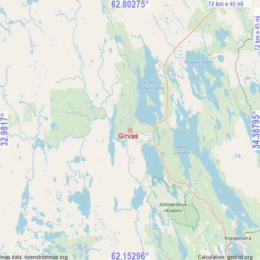
Girvas GPS coordinates[2]
62° 28' 46.632" North, 33° 41' 5.352" East
| Map corner | latitude | longitude |
|---|---|---|
| Upper-left | 62.80275°, | 32.9817° |
| Center: | 62.47962°, | 33.68482° |
| Lower-right: | 62.15296°, | 34.38795° |
| Map W x H: | 72.2×72.2 km | = 44.9×44.9mi |
| max Lat: | 73.50819° ⇑4.4% North |
| Girvas: | 62.47962° |
| min Lat: | ⇓95.6% South 41.28413° |
| min Long | Girvas | max Long |
| -179.12198° | 33.68482° | 179.35046° |
| W 9%⇐ | ⇒91% E |
Elevation
Elevation of Girvas is 88 m = 289 ft, and this is 114.6 m = 376 ft below average elevation for this country.
| Max E: |
2518 m = 8261 ft | 75% |
| Avg. | 202.6 m = 665 ft | |
| Girvas | 88 m = 289 ft | |
Min E: |
-28 m = -92 ft | 25% |
See also: Russia elevation on elevation.city.
Geographical zone
Girvas is located in North temperate zone (between Tropic of Cancer and the Arctic Circle). Distance of this North polar circle is 454.1 km =282.2 mi to North.| Distance of | km | miles | from Girvas |
|---|---|---|---|
| North Pole | 3060 | 1901.4 | to North |
| Arctic Circle | 454.1 | 282.2 | to North |
| Tropic Cancer | 4341.2 | 2697.5 | to South |
| Equator | 6947.1 | 4316.7 | to South |


Nearby cities:
15 places around Girvas: (largest is in red/bold)
• Essoyla
73.3 km =45.5 mi,  202°
202°
• Kondopoga
42.6 km =26.5 mi,  135°
135°
• Matrosy
78 km =48.5 mi,  175°
175°
• Medvezh’yegorsk
62.6 km =38.9 mi,  38°
38°
• Petrozavodsk
84.6 km =52.6 mi,  155°
155°
• Pindushi
66.6 km =41.4 mi, 43°
• Porosozero
55.8 km =34.7 mi,  298°
298°
• Povenets
71.3 km =44.3 mi,  54°
54°
• Pryazha
87.6 km =54.4 mi, 182°
• Shun’ga
66.1 km =41.1 mi,  78°
78°
• Shuya
65.1 km =40.5 mi,  154°
154°
• Suoyarvi
81.9 km =50.9 mi,  237°
237°
• Syapsya
63.9 km =39.7 mi,  194°
194°
• Veshkelitsa
76.8 km =47.7 mi,  216°
216°
• Yanishpole
50.9 km =31.6 mi, 143°
Sources, notices
• [Note1] Compared only with cities in Russia existing in our database
• [Src1] Map data: © OpenStreetMap contributors (CC-BY-SA)
• [Src2] Other city data from geonames.org with taken over terms of usage.
• [Src3] Geographical zone / Annual Mean Temperature by Robert A. Rohde @ Wikipedia
