Vesëlyy geodata
Vesëlyy (Rostov) is a seat of a second-order administrative division; located in Russia in Europe/Moscow (GMT+3) time zone. With population of 8,820 people, there are 1681 cities with bigger population in this country. Compared to other cities in Russia, 82.1% of cities are located further ↑North; 64% of cities are located further →East and 96.4% of cities have higher elevation than Vesëlyy. Note1


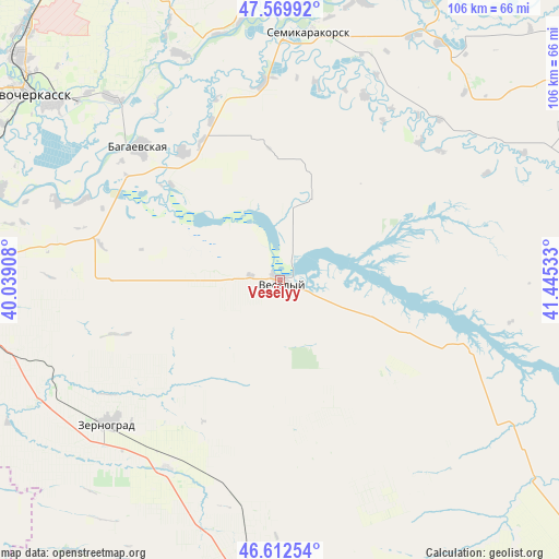
Vesëlyy GPS coordinates[2]
47° 5' 36.168" North, 40° 44' 31.92" East
| Map corner | latitude | longitude |
|---|---|---|
| Upper-left | 47.56992°, | 40.03908° |
| Center: | 47.09338°, | 40.7422° |
| Lower-right: | 46.61254°, | 41.44533° |
| Map W x H: | 106.5×106.4 km | = 66.2×66.1mi |
| max Lat: | 73.50819° ⇑82.1% North |
| Vesëlyy: | 47.09338° |
| min Lat: | ⇓17.9% South 41.28413° |
| min Long | Vesëlyy | max Long |
| -179.12198° | 40.7422° | 179.35046° |
| W 36%⇐ | ⇒64% E |
Elevation
Elevation of Vesëlyy is 9 m = 30 ft, and this is 193.6 m = 635 ft below average elevation for this country.
| Max E: |
2518 m = 8261 ft | 96.4% |
| Avg. | 202.6 m = 665 ft | |
| Vesëlyy | 9 m = 30 ft | |
Min E: |
-28 m = -92 ft | 3.6% |
See also: Russia elevation on elevation.city.
Geographical zone
Vesëlyy is located in North temperate zone (between Tropic of Cancer and the Arctic Circle). Distance of this North polar circle is 2164.9 km =1345.2 mi to North.| Distance of | km | miles | from Vesëlyy |
|---|---|---|---|
| North Pole | 4770.8 | 2964.4 | to North |
| Arctic Circle | 2164.9 | 1345.2 | to North |
| Tropic Cancer | 2630.4 | 1634.5 | to South |
| Equator | 5236.3 | 3253.7 | to South |


Nearby cities:
15 places around Vesëlyy: (largest is in red/bold)
• Bagayevskaya
37.1 km =23.1 mi,  313°
313°
• Donskoy
51.1 km =31.8 mi, 314°
• Kagal’nitskaya
51 km =31.7 mi,  242°
242°
• Kirovskaya
54.8 km =34.1 mi,  256°
256°
• Konstantinovsk
60.5 km =37.6 mi,  25°
25°
• Krivyanskaya
55 km =34.2 mi, 307°
• Mechetinskaya
41.9 km =26 mi,  211°
211°
• Melikhovskaya
47.2 km =29.3 mi,  335°
335°
• Novocherkassk
61.1 km =38 mi, 306°
• Ol’ginskaya
60.9 km =37.8 mi,  279°
279°
• Rassvet
28.9 km =18 mi,  178°
178°
• Semikarakorsk
47.3 km =29.4 mi,  5°
5°
• Starocherkasskaya
55.4 km =34.4 mi,  287°
287°
• Yegorlykskaya
59 km =36.7 mi,  186°
186°
• Zernograd
43 km =26.7 mi,  230°
230°
Sources, notices
• [Note1] Compared only with cities in Russia existing in our database
• [Src1] Map data: © OpenStreetMap contributors (CC-BY-SA)
• [Src2] Other city data from geonames.org with taken over terms of usage.
• [Src3] Geographical zone / Annual Mean Temperature by Robert A. Rohde @ Wikipedia
