Kagal’nitskaya geodata
Kagal’nitskaya (Rostov) is a seat of a second-order administrative division; located in Russia in Europe/Moscow (GMT+3) time zone. With population of 6,848 people, there are 2037 cities with bigger population in this country. Compared to other cities in Russia, 82.3% of cities are located further ↑North; 66.8% of cities are located further →East and 90.5% of cities have higher elevation than Kagal’nitskaya. Note1


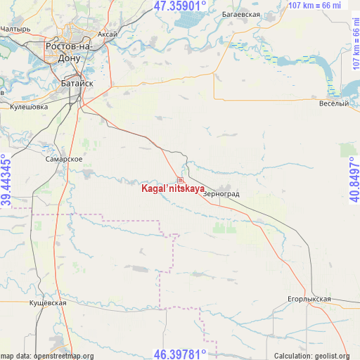
Kagal’nitskaya GPS coordinates[2]
46° 52' 50.016" North, 40° 8' 47.652" East
| Map corner | latitude | longitude |
|---|---|---|
| Upper-left | 47.35901°, | 39.44345° |
| Center: | 46.88056°, | 40.14657° |
| Lower-right: | 46.39781°, | 40.8497° |
| Map W x H: | 106.9×106.9 km | = 66.4×66.4mi |
| max Lat: | 73.50819° ⇑82.3% North |
| Kagal’nitskaya: | 46.88056° |
| min Lat: | ⇓17.7% South 41.28413° |
| min Long | Kagal’nitskay | max Long |
| -179.12198° | 40.14657° | 179.35046° |
| W 33.2%⇐ | ⇒66.8% E |
Elevation
Elevation of Kagal’nitskaya is 27 m = 89 ft, and this is 175.6 m = 576 ft below average elevation for this country.
| Max E: |
2518 m = 8261 ft | 90.5% |
| Avg. | 202.6 m = 665 ft | |
| Kagal’nitskaya | 27 m = 89 ft | |
Min E: |
-28 m = -92 ft | 9.5% |
See also: Russia elevation on elevation.city.
Geographical zone
Kagal’nitskaya is located in North temperate zone (between Tropic of Cancer and the Arctic Circle). Distance of this North polar circle is 2188.5 km =1359.9 mi to North.| Distance of | km | miles | from Kagal’nitskaya |
|---|---|---|---|
| North Pole | 4794.4 | 2979.1 | to North |
| Arctic Circle | 2188.5 | 1359.9 | to North |
| Tropic Cancer | 2606.7 | 1619.7 | to South |
| Equator | 5212.6 | 3239 | to South |


Nearby cities:
15 places around Kagal’nitskaya: (largest is in red/bold)
• Aksay
47.1 km =29.3 mi,  333°
333°
• Bataysk
41.5 km =25.8 mi,  313°
313°
• Kirovskaya
13.2 km =8.2 mi,  322°
322°
• Krasnoye
47.1 km =29.3 mi,  250°
250°
• Kuleshovka
49.8 km =30.9 mi,  296°
296°
• Mechetinskaya
26.5 km =16.5 mi,  117°
117°
• Novobataysk
27.8 km =17.3 mi,  274°
274°
• Ol’ginskaya
37.3 km =23.2 mi,  336°
336°
• Rassvet
46.2 km =28.7 mi,  96°
96°
• Rostov-na-Donu
50.5 km =31.4 mi, 320°
• Samarskoye
35.4 km =22 mi,  280°
280°
• Starocherkasskaya
40.8 km =25.4 mi,  348°
348°
• Vesëlyy
51 km =31.7 mi,  62°
62°
• Yegorlykskaya
52.3 km =32.5 mi,  132°
132°
• Zernograd
12.9 km =8 mi,  107°
107°
Sources, notices
• [Note1] Compared only with cities in Russia existing in our database
• [Src1] Map data: © OpenStreetMap contributors (CC-BY-SA)
• [Src2] Other city data from geonames.org with taken over terms of usage.
• [Src3] Geographical zone / Annual Mean Temperature by Robert A. Rohde @ Wikipedia
