Zernograd geodata
Zernograd (Rostov) is a seat of a second-order administrative division; located in Russia in Europe/Moscow (GMT+3) time zone. With population of 29,268 people, there are 674 cities with bigger population in this country. Compared to other cities in Russia, 82.4% of cities are located further ↑North; 66% of cities are located further →East and 75.3% of cities have higher elevation than Zernograd. Note1


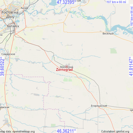
Zernograd GPS coordinates[2]
46° 50' 42.648" North, 40° 18' 30.024" East
| Map corner | latitude | longitude |
|---|---|---|
| Upper-left | 47.32395°, | 39.60522° |
| Center: | 46.84518°, | 40.30834° |
| Lower-right: | 46.36211°, | 41.01147° |
| Map W x H: | 106.9×106.9 km | = 66.4×66.4mi |
| max Lat: | 73.50819° ⇑82.4% North |
| Zernograd: | 46.84518° |
| min Lat: | ⇓17.6% South 41.28413° |
| min Long | Zernograd | max Long |
| -179.12198° | 40.30834° | 179.35046° |
| W 34%⇐ | ⇒66% E |
Elevation
Elevation of Zernograd is 87 m = 285 ft, and this is 115.6 m = 379 ft below average elevation for this country.
| Max E: |
2518 m = 8261 ft | 75.3% |
| Avg. | 202.6 m = 665 ft | |
| Zernograd | 87 m = 285 ft | |
Min E: |
-28 m = -92 ft | 24.7% |
See also: Russia elevation on elevation.city.
Geographical zone
Zernograd is located in North temperate zone (between Tropic of Cancer and the Arctic Circle). Distance of this North polar circle is 2192.5 km =1362.4 mi to North.| Distance of | km | miles | from Zernograd |
|---|---|---|---|
| North Pole | 4798.4 | 2981.6 | to North |
| Arctic Circle | 2192.5 | 1362.4 | to North |
| Tropic Cancer | 2602.8 | 1617.3 | to South |
| Equator | 5208.7 | 3236.5 | to South |


Nearby cities:
15 places around Zernograd: (largest is in red/bold)
• Aksay
56.8 km =35.3 mi,  323°
323°
• Bagayevskaya
53.6 km =33.3 mi,  6°
6°
• Bataysk
53.4 km =33.2 mi,  307°
307°
• Kagal’nitskaya
12.9 km =8 mi,  287°
287°
• Kirovskaya
25 km =15.5 mi, 305°
• Krasnoye
57.9 km =36 mi,  258°
258°
• Kushchëvskaya
60.5 km =37.6 mi,  238°
238°
• Mechetinskaya
13.9 km =8.6 mi,  126°
126°
• Novobataysk
40.4 km =25.1 mi,  278°
278°
• Ol’ginskaya
46.8 km =29.1 mi, 324°
• Rassvet
33.6 km =20.9 mi,  92°
92°
• Samarskoye
48.2 km =30 mi, 282°
• Starocherkasskaya
48.4 km =30.1 mi,  335°
335°
• Vesëlyy
43 km =26.7 mi,  50°
50°
• Yegorlykskaya
40.9 km =25.4 mi,  139°
139°
Sources, notices
• [Note1] Compared only with cities in Russia existing in our database
• [Src1] Map data: © OpenStreetMap contributors (CC-BY-SA)
• [Src2] Other city data from geonames.org with taken over terms of usage.
• [Src3] Geographical zone / Annual Mean Temperature by Robert A. Rohde @ Wikipedia
