Velikovechnoye geodata
Velikovechnoye (Krasnodarskiy) is a populated place; located in Russia in Europe/Moscow (GMT+3) time zone. With population of 5,762 people, there are 2343 cities with bigger population in this country. Compared to other cities in Russia, 87.6% of cities are located further ↑North; 68.7% of cities are located further →East and 80.3% of cities have higher elevation than Velikovechnoye. Note1


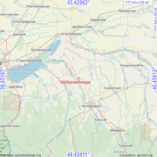
Velikovechnoye GPS coordinates[2]
44° 56' 2.472" North, 39° 45' 17.964" East
| Map corner | latitude | longitude |
|---|---|---|
| Upper-left | 45.42962°, | 39.05187° |
| Center: | 44.93402°, | 39.75499° |
| Lower-right: | 44.43411°, | 40.45812° |
| Map W x H: | 110.7×110.7 km | = 68.8×68.8mi |
| max Lat: | 73.50819° ⇑87.6% North |
| Velikovechnoye: | 44.93402° |
| min Lat: | ⇓12.4% South 41.28413° |
| min Long | Velikovechnoye | max Long |
| -179.12198° | 39.75499° | 179.35046° |
| W 31.3%⇐ | ⇒68.7% E |
Elevation
Elevation of Velikovechnoye is 70 m = 230 ft, and this is 132.6 m = 435 ft below average elevation for this country.
| Max E: |
2518 m = 8261 ft | 80.3% |
| Avg. | 202.6 m = 665 ft | |
| Velikovechnoye | 70 m = 230 ft | |
Min E: |
-28 m = -92 ft | 19.7% |
See also: Russia elevation on elevation.city.
Geographical zone
Velikovechnoye is located in North temperate zone (between Tropic of Cancer and the Arctic Circle). Distance of this Northern Tropic circle is 2390.3 km =1485.3 mi to South.| Distance of | km | miles | from Velikovechnoye |
|---|---|---|---|
| North Pole | 5010.9 | 3113.6 | to North |
| Arctic Circle | 2405 | 1494.4 | to North |
| Tropic Cancer | 2390.3 | 1485.3 | to South |
| Equator | 4996.2 | 3104.5 | to South |


Nearby cities:
15 places around Velikovechnoye: (largest is in red/bold)
• Belorechensk
20.6 km =12.8 mi,  151°
151°
• Beloye
15.1 km =9.4 mi,  327°
327°
• Dvubratskiy
34.1 km =21.2 mi,  6°
6°
• Giaginskaya
26.2 km =16.3 mi,  107°
107°
• Khanskaya
32.9 km =20.4 mi, 150°
• Khatukay
29.4 km =18.3 mi,  345°
345°
• Krasnogvardeyskoye
25.9 km =16.1 mi, 326°
• Nekrasovskaya
23.4 km =14.5 mi,  358°
358°
• Novolabinskaya
22.4 km =13.9 mi,  29°
29°
• Ponezhukay
29.5 km =18.3 mi,  259°
259°
• Pshekhskaya
26.7 km =16.6 mi,  172°
172°
• Ryazanskaya
13.3 km =8.3 mi,  280°
280°
• Ust’-Labinsk
31.2 km =19.4 mi, 350°
• Vasyurinskaya
33.1 km =20.6 mi,  308°
308°
• Yuzhnyy
25.6 km =15.9 mi,  157°
157°
Sources, notices
• [Note1] Compared only with cities in Russia existing in our database
• [Src1] Map data: © OpenStreetMap contributors (CC-BY-SA)
• [Src2] Other city data from geonames.org with taken over terms of usage.
• [Src3] Geographical zone / Annual Mean Temperature by Robert A. Rohde @ Wikipedia
