Krasnogvardeyskoye geodata
Krasnogvardeyskoye (Adygeya Republic) is a seat of a second-order administrative division; located in Russia in Europe/Moscow (GMT+3) time zone. With population of 9,071 people, there are 1643 cities with bigger population in this country. Compared to other cities in Russia, 86.7% of cities are located further ↑North; 69.7% of cities are located further →East and 88.8% of cities have higher elevation than Krasnogvardeyskoye. Note1


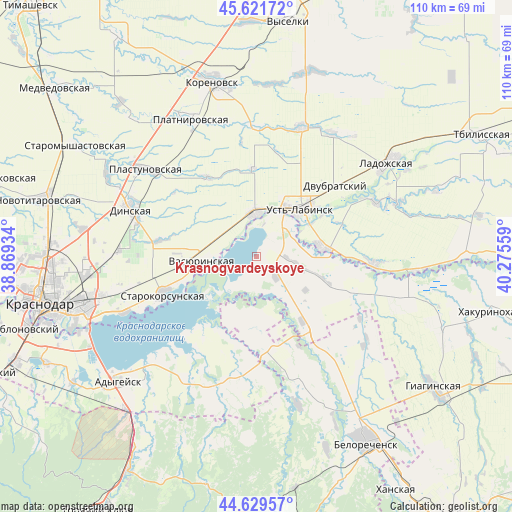
Krasnogvardeyskoye GPS coordinates[2]
45° 7' 40.08" North, 39° 34' 20.856" East
| Map corner | latitude | longitude |
|---|---|---|
| Upper-left | 45.62172°, | 38.86934° |
| Center: | 45.1278°, | 39.57246° |
| Lower-right: | 44.62957°, | 40.27559° |
| Map W x H: | 110.3×110.3 km | = 68.5×68.5mi |
| max Lat: | 73.50819° ⇑86.7% North |
| Krasnogvardeyskoye: | 45.1278° |
| min Lat: | ⇓13.3% South 41.28413° |
| min Long | Krasnogvardeysk | max Long |
| -179.12198° | 39.57246° | 179.35046° |
| W 30.3%⇐ | ⇒69.7% E |
Elevation
Elevation of Krasnogvardeyskoye is 33 m = 108 ft, and this is 169.6 m = 556 ft below average elevation for this country.
| Max E: |
2518 m = 8261 ft | 88.8% |
| Avg. | 202.6 m = 665 ft | |
| Krasnogvardeyskoye | 33 m = 108 ft | |
Min E: |
-28 m = -92 ft | 11.2% |
See also: Russia elevation on elevation.city.
Geographical zone
Krasnogvardeyskoye is located in North temperate zone (between Tropic of Cancer and the Arctic Circle). Distance of this North polar circle is 2383.4 km =1481 mi to North.| Distance of | km | miles | from Krasnogvardeyskoye |
|---|---|---|---|
| North Pole | 4989.3 | 3100.2 | to North |
| Arctic Circle | 2383.4 | 1481 | to North |
| Tropic Cancer | 2411.8 | 1498.6 | to South |
| Equator | 5017.7 | 3117.9 | to South |


Nearby cities:
15 places around Krasnogvardeyskoye: (largest is in red/bold)
• Agronom
29.7 km =18.5 mi,  272°
272°
• Beloye
10.8 km =6.7 mi,  144°
144°
• Dinskaya
28.8 km =17.9 mi,  289°
289°
• Dvubratskiy
22 km =13.7 mi,  55°
55°
• Khatukay
10 km =6.2 mi,  45°
45°
• Nekrasovskaya
13.9 km =8.6 mi,  82°
82°
• Novolabinskaya
25.3 km =15.7 mi,  94°
94°
• Plastunovskaya
30.4 km =18.9 mi,  307°
307°
• Platnirovskaya
33.2 km =20.6 mi,  333°
333°
• Ponezhukay
30.5 km =19 mi,  208°
208°
• Ryazanskaya
19.2 km =11.9 mi,  176°
176°
• Starokorsunskaya
21.6 km =13.4 mi,  248°
248°
• Ust’-Labinsk
13 km =8.1 mi,  44°
44°
• Vasyurinskaya
11.7 km =7.3 mi,  264°
264°
• Velikovechnoye
25.9 km =16.1 mi,  146°
146°
Sources, notices
• [Note1] Compared only with cities in Russia existing in our database
• [Src1] Map data: © OpenStreetMap contributors (CC-BY-SA)
• [Src2] Other city data from geonames.org with taken over terms of usage.
• [Src3] Geographical zone / Annual Mean Temperature by Robert A. Rohde @ Wikipedia
