Belorechensk geodata
Belorechensk (Krasnodarskiy) is a seat of a second-order administrative division; located in Russia in Europe/Moscow (GMT+3) time zone. With population of 54,526 people, there are 386 cities with bigger population in this country. Compared to other cities in Russia, 88.5% of cities are located further ↑North; 68.1% of cities are located further →East and 63% of cities have higher elevation than Belorechensk. Note1


Belorechensk GPS coordinates[2]
44° 46' 16.572" North, 39° 52' 43.644" East
| Map corner | latitude | longitude |
|---|---|---|
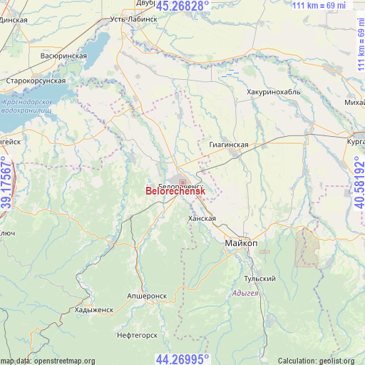
| Upper-left | 45.26828°, | 39.17567° |
| Center: | 44.77127°, | 39.87879° |
| Lower-right: | 44.26995°, | 40.58192° |
| Map W x H: | 111×111 km | = 69×69mi |
| max Lat: | 73.50819° ⇑88.5% North |
| Belorechensk: | 44.77127° |
| min Lat: | ⇓11.5% South 41.28413° |
| min Long | Belorechensk | max Long |
| -179.12198° | 39.87879° | 179.35046° |
| W 31.9%⇐ | ⇒68.1% E |
Elevation
Elevation of Belorechensk is 118 m = 387 ft, and this is 84.6 m = 278 ft below average elevation for this country.
| Max E: |
2518 m = 8261 ft | 63% |
| Avg. | 202.6 m = 665 ft | |
| Belorechensk | 118 m = 387 ft | |
Min E: |
-28 m = -92 ft | 37% |
See also: Belorechensk elevation on elevation.city.
Geographical zone
Belorechensk is located in North temperate zone (between Tropic of Cancer and the Arctic Circle). Distance of this Northern Tropic circle is 2372.2 km =1474 mi to South.| Distance of | km | miles | from Belorechensk |
|---|---|---|---|
| North Pole | 5029 | 3124.9 | to North |
| Arctic Circle | 2423.1 | 1505.6 | to North |
| Tropic Cancer | 2372.2 | 1474 | to South |
| Equator | 4978.1 | 3093.2 | to South |


Nearby cities:
15 places around Belorechensk: (largest is in red/bold)
• Apsheronsk
36 km =22.4 mi,  198°
198°
• Beloye
35.6 km =22.1 mi,  329°
329°
• Dondukovskaya
40.1 km =24.9 mi,  72°
72°
• Giaginskaya
18.3 km =11.4 mi,  56°
56°
• Khanskaya
12.4 km =7.7 mi,  148°
148°
• Kuzhorskaya
35.7 km =22.2 mi,  107°
107°
• Maykop
25.5 km =15.8 mi,  135°
135°
• Novolabinskaya
37.6 km =23.4 mi,  1°
1°
• Ponezhukay
41 km =25.5 mi,  288°
288°
• Pshekhskaya
10.6 km =6.6 mi,  217°
217°
• Ryazanskaya
30.7 km =19.1 mi,  311°
311°
• Shovgenovskiy
38.1 km =23.7 mi,  45°
45°
• Tul’skiy
37.2 km =23.1 mi, 140°
• Velikovechnoye
20.6 km =12.8 mi, 331°
• Yuzhnyy
5.6 km =3.5 mi,  179°
179°
In other languages:
- In Spanish: Beloréchensk
- In France: Beloretchensk
- In German: Beloretschensk
- In Italian: Belorečensk
- In Russian: Белореченск
- In Chinese: 別洛列琴斯克
Sources, notices
• [Note1] Compared only with cities in Russia existing in our database
• [Src1] Map data: © OpenStreetMap contributors (CC-BY-SA)
• [Src2] Other city data from geonames.org with taken over terms of usage.
• [Src3] Geographical zone / Annual Mean Temperature by Robert A. Rohde @ Wikipedia
