Urshel’skiy geodata
Urshel’skiy (Vladimir) is a populated place; located in Russia in Europe/Moscow (GMT+3) time zone. With population of 4,683 people, there are 2790 cities with bigger population in this country. Compared to other cities in Russia, 61.2% of cities are located further ↓South; 66.4% of cities are located further →East and 52.6% of cities have higher elevation than Urshel’skiy. Note1


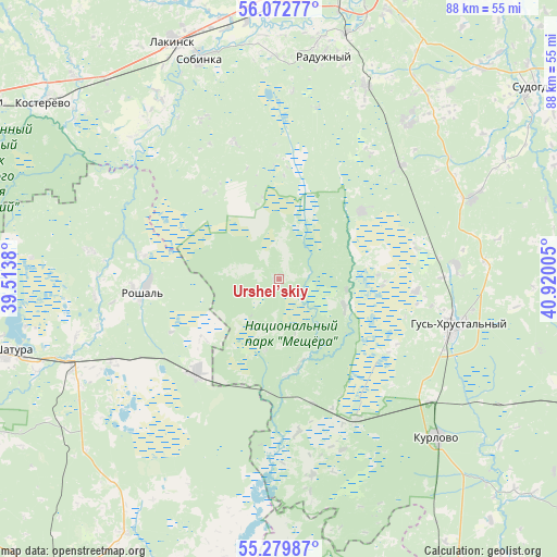
Urshel’skiy GPS coordinates[2]
55° 40' 41.988" North, 40° 13' 0.912" East
| Map corner | latitude | longitude |
|---|---|---|
| Upper-left | 56.07277°, | 39.5138° |
| Center: | 55.67833°, | 40.21692° |
| Lower-right: | 55.27987°, | 40.92005° |
| Map W x H: | 88.2×88.2 km | = 54.8×54.8mi |
| max Lat: | 73.50819° ⇑38.8% North |
| Urshel’skiy: | 55.67833° |
| min Lat: | ⇓61.2% South 41.28413° |
| min Long | Urshel’skiy | max Long |
| -179.12198° | 40.21692° | 179.35046° |
| W 33.6%⇐ | ⇒66.4% E |
Elevation
Elevation of Urshel’skiy is 139 m = 456 ft, and this is 63.6 m = 209 ft below average elevation for this country.
| Max E: |
2518 m = 8261 ft | 52.6% |
| Avg. | 202.6 m = 665 ft | |
| Urshel’skiy | 139 m = 456 ft | |
Min E: |
-28 m = -92 ft | 47.4% |
See also: Russia elevation on elevation.city.
Geographical zone
Urshel’skiy is located in North temperate zone (between Tropic of Cancer and the Arctic Circle). Distance of this North polar circle is 1210.3 km =752 mi to North.| Distance of | km | miles | from Urshel’skiy |
|---|---|---|---|
| North Pole | 3816.2 | 2371.3 | to North |
| Arctic Circle | 1210.3 | 752 | to North |
| Tropic Cancer | 3584.9 | 2227.6 | to South |
| Equator | 6190.8 | 3846.8 | to South |


Nearby cities:
15 places around Urshel’skiy: (largest is in red/bold)
• Anopino
28.3 km =17.6 mi,  85°
85°
• Baksheyevo
21.6 km =13.4 mi,  278°
278°
• Cherusti
19.3 km =12 mi,  222°
222°
• Erleks
13.5 km =8.4 mi,  128°
128°
• Golovino
34 km =21.1 mi,  22°
22°
• Gusevskiy
21.8 km =13.5 mi, 94°
• Gus’-Khrustal’nyy
28.3 km =17.6 mi,  105°
105°
• Ivanishchi
16.9 km =10.5 mi,  51°
51°
• Kurlovo
32.1 km =19.9 mi,  148°
148°
• Mezinovskiy
21.3 km =13.2 mi,  155°
155°
• Misheronskiy
30.3 km =18.8 mi, 278°
• Raduzhnyy
37 km =23 mi,  11°
11°
• Roshal’
21.5 km =13.4 mi,  267°
267°
• Sobinka
36.5 km =22.7 mi,  339°
339°
• Tugolesskiy Bor
28.5 km =17.7 mi,  240°
240°
Sources, notices
• [Note1] Compared only with cities in Russia existing in our database
• [Src1] Map data: © OpenStreetMap contributors (CC-BY-SA)
• [Src2] Other city data from geonames.org with taken over terms of usage.
• [Src3] Geographical zone / Annual Mean Temperature by Robert A. Rohde @ Wikipedia
