Cherusti geodata
Cherusti (Moscow Oblast) is a populated place; located in Russia in Europe/Moscow (GMT+3) time zone. With population of 2,867 people, there are 3841 cities with bigger population in this country. Compared to other cities in Russia, 58.6% of cities are located further ↓South; 67.5% of cities are located further →East and 59.2% of cities have higher elevation than Cherusti. Note1


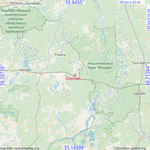
Cherusti GPS coordinates[2]
55° 32' 59.136" North, 40° 0' 38.556" East
| Map corner | latitude | longitude |
|---|---|---|
| Upper-left | 55.9455°, | 39.30759° |
| Center: | 55.54976°, | 40.01071° |
| Lower-right: | 55.14999°, | 40.71384° |
| Map W x H: | 88.5×88.5 km | = 55×55mi |
| max Lat: | 73.50819° ⇑41.4% North |
| Cherusti: | 55.54976° |
| min Lat: | ⇓58.6% South 41.28413° |
| min Long | Cherusti | max Long |
| -179.12198° | 40.01071° | 179.35046° |
| W 32.5%⇐ | ⇒67.5% E |
Elevation
Elevation of Cherusti is 126 m = 413 ft, and this is 76.6 m = 251 ft below average elevation for this country.
| Max E: |
2518 m = 8261 ft | 59.2% |
| Avg. | 202.6 m = 665 ft | |
| Cherusti | 126 m = 413 ft | |
Min E: |
-28 m = -92 ft | 40.8% |
See also: Russia elevation on elevation.city.
Geographical zone
Cherusti is located in North temperate zone (between Tropic of Cancer and the Arctic Circle). Distance of this North polar circle is 1224.6 km =760.9 mi to North.| Distance of | km | miles | from Cherusti |
|---|---|---|---|
| North Pole | 3830.5 | 2380.2 | to North |
| Arctic Circle | 1224.6 | 760.9 | to North |
| Tropic Cancer | 3570.6 | 2218.7 | to South |
| Equator | 6176.6 | 3838 | to South |


Nearby cities:
15 places around Cherusti: (largest is in red/bold)
• Baksheyevo
19.6 km =12.2 mi,  334°
334°
• Dmitrovskiy Pogost
28.6 km =17.8 mi,  203°
203°
• Erleks
24.2 km =15 mi,  76°
76°
• Gusevskiy
36.8 km =22.9 mi,  70°
70°
• Ivanishchi
36.1 km =22.4 mi,  46°
46°
• Kerva
28.1 km =17.5 mi,  284°
284°
• Kurlovo
32.6 km =20.3 mi,  113°
113°
• Mezinovskiy
22.5 km =14 mi,  103°
103°
• Misheronskiy
25.4 km =15.8 mi,  317°
317°
• Roshal’
15.7 km =9.8 mi, 327°
• Savinskaya
20 km =12.4 mi,  183°
183°
• Shatura
29.9 km =18.6 mi,  274°
274°
• Shaturtorf
37.1 km =23.1 mi, 272°
• Tugolesskiy Bor
11.7 km =7.3 mi, 270°
• Urshel’skiy
19.3 km =12 mi,  42°
42°
Sources, notices
• [Note1] Compared only with cities in Russia existing in our database
• [Src1] Map data: © OpenStreetMap contributors (CC-BY-SA)
• [Src2] Other city data from geonames.org with taken over terms of usage.
• [Src3] Geographical zone / Annual Mean Temperature by Robert A. Rohde @ Wikipedia
