Roshal’ geodata
Roshal’ (Moscow Oblast) is a populated place; located in Russia in Europe/Moscow (GMT+3) time zone. With population of 21,951 people, there are 818 cities with bigger population in this country. Compared to other cities in Russia, 61% of cities are located further ↓South; 68.2% of cities are located further →East and 63.5% of cities have higher elevation than Roshal’. Note1


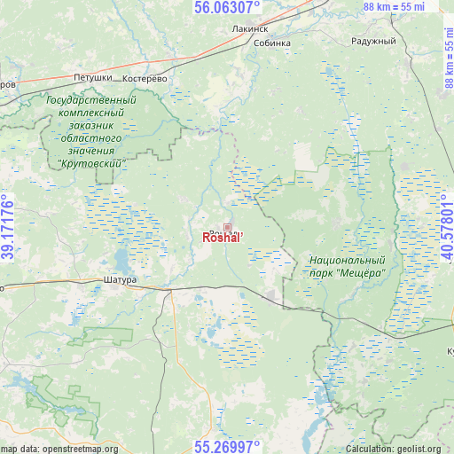
Roshal’ GPS coordinates[2]
55° 40' 6.708" North, 39° 52' 29.568" East
| Map corner | latitude | longitude |
|---|---|---|
| Upper-left | 56.06307°, | 39.17176° |
| Center: | 55.66853°, | 39.87488° |
| Lower-right: | 55.26997°, | 40.57801° |
| Map W x H: | 88.2×88.2 km | = 54.8×54.8mi |
| max Lat: | 73.50819° ⇑39% North |
| Roshal’: | 55.66853° |
| min Lat: | ⇓61% South 41.28413° |
| min Long | Roshal’ | max Long |
| -179.12198° | 39.87488° | 179.35046° |
| W 31.8%⇐ | ⇒68.2% E |
Elevation
Elevation of Roshal’ is 117 m = 384 ft, and this is 85.6 m = 281 ft below average elevation for this country.
| Max E: |
2518 m = 8261 ft | 63.5% |
| Avg. | 202.6 m = 665 ft | |
| Roshal’ | 117 m = 384 ft | |
Min E: |
-28 m = -92 ft | 36.5% |
See also: Russia elevation on elevation.city.
Geographical zone
Roshal’ is located in North temperate zone (between Tropic of Cancer and the Arctic Circle). Distance of this North polar circle is 1211.4 km =752.7 mi to North.| Distance of | km | miles | from Roshal’ |
|---|---|---|---|
| North Pole | 3817.3 | 2372 | to North |
| Arctic Circle | 1211.4 | 752.7 | to North |
| Tropic Cancer | 3583.8 | 2226.9 | to South |
| Equator | 6189.8 | 3846.2 | to South |


Nearby cities:
15 places around Roshal’: (largest is in red/bold)
• Baksheyevo
4.5 km =2.8 mi,  1°
1°
• Cherusti
15.7 km =9.8 mi,  147°
147°
• Erleks
32.9 km =20.4 mi,  102°
102°
• Ivanishchi
36.5 km =22.7 mi,  71°
71°
• Kerva
19.8 km =12.3 mi,  251°
251°
• Kosterevo
33.3 km =20.7 mi,  330°
330°
• Mezinovskiy
35.5 km =22.1 mi,  120°
120°
• Misheronskiy
10.2 km =6.3 mi,  303°
303°
• Petushki
38.6 km =24 mi,  317°
317°
• Savinskaya
34 km =21.1 mi,  167°
167°
• Shatura
23.8 km =14.8 mi,  243°
243°
• Shaturtorf
30.6 km =19 mi, 248°
• Sobinka
36.3 km =22.6 mi,  13°
13°
• Tugolesskiy Bor
13.5 km =8.4 mi,  193°
193°
• Urshel’skiy
21.5 km =13.4 mi,  87°
87°
Sources, notices
• [Note1] Compared only with cities in Russia existing in our database
• [Src1] Map data: © OpenStreetMap contributors (CC-BY-SA)
• [Src2] Other city data from geonames.org with taken over terms of usage.
• [Src3] Geographical zone / Annual Mean Temperature by Robert A. Rohde @ Wikipedia
