Gergebil’ geodata
Gergebil’ (Dagestan) is a populated place; located in Russia in Europe/Moscow (GMT+3) time zone. With population of 5,107 people, there are 2605 cities with bigger population in this country. Compared to other cities in Russia, 98.9% of cities are located further ↑North; 56.2% of cities are located further ←West and 96.5% of cities have lower elevation than Gergebil’. Note1


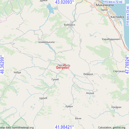
Gergebil’ GPS coordinates[2]
42° 30' 16.992" North, 47° 3' 57.996" East
| Map corner | latitude | longitude |
|---|---|---|
| Upper-left | 43.02093°, | 46.36299° |
| Center: | 42.50472°, | 47.06611° |
| Lower-right: | 41.98421°, | 47.76924° |
| Map W x H: | 115.3×115.3 km | = 71.6×71.6mi |
| max Lat: | 73.50819° ⇑98.9% North |
| Gergebil’: | 42.50472° |
| min Lat: | ⇓1.1% South 41.28413° |
| min Long | Gergebil’ | max Long |
| -179.12198° | 47.06611° | 179.35046° |
| W 56.2%⇐ | ⇒43.8% E |
Elevation
Elevation of Gergebil’ is 729 m = 2392 ft, and this is 526.4 m = 1727 ft above average elevation for this country.
| Max E: |
2518 m = 8261 ft | 3.5% |
| Gergebil’ | 729 m 2392 ft | |
| Avg. | 202.6 m = 665 ft | |
Min E: |
-28 m = -92 ft | 96.5% |
See also: Russia elevation on elevation.city.
Geographical zone
Gergebil’ is located in North temperate zone (between Tropic of Cancer and the Arctic Circle). Distance of this Northern Tropic circle is 2120.2 km =1317.4 mi to South.| Distance of | km | miles | from Gergebil’ |
|---|---|---|---|
| North Pole | 5281 | 3281.5 | to North |
| Arctic Circle | 2675.1 | 1662.2 | to North |
| Tropic Cancer | 2120.2 | 1317.4 | to South |
| Equator | 4726.1 | 2936.7 | to South |


Nearby cities:
15 places around Gergebil’: (largest is in red/bold)
• Dorgeli
26 km =16.2 mi,  45°
45°
• Gimry
33.9 km =21.1 mi,  326°
326°
• Gunib
15.4 km =9.6 mi,  212°
212°
• Irganay
20.2 km =12.6 mi,  321°
321°
• Karamakhi
20.4 km =12.7 mi, 51°
• Khadzhalmakhi
13.4 km =8.3 mi,  134°
134°
• Khunzakh
29.7 km =18.5 mi,  278°
278°
• Levashi
22.5 km =14 mi,  111°
111°
• Nizhneye Kazanishche
29.8 km =18.5 mi,  14°
14°
• Nizhniy Dzhengutay
26.2 km =16.3 mi,  33°
33°
• Shamil’kala
26.1 km =16.2 mi, 320°
• Ulluaya
29.2 km =18.1 mi,  119°
119°
• Untsukul’
32.4 km =20.1 mi, 315°
• Urma
18.4 km =11.4 mi,  78°
78°
• Verkhneye Kazanishche
26.3 km =16.3 mi, 12°
Sources, notices
• [Note1] Compared only with cities in Russia existing in our database
• [Src1] Map data: © OpenStreetMap contributors (CC-BY-SA)
• [Src2] Other city data from geonames.org with taken over terms of usage.
• [Src3] Geographical zone / Annual Mean Temperature by Robert A. Rohde @ Wikipedia
