Kholm-Zhirkovskiy geodata
Kholm-Zhirkovskiy (Smolensk) is a populated place; located in Russia in Europe/Moscow (GMT+3) time zone. With population of 3,726 people, there are 3250 cities with bigger population in this country. Compared to other cities in Russia, 58.3% of cities are located further ↓South; 91.3% of cities are located further →East and 76.9% of cities have lower elevation than Kholm-Zhirkovskiy. Note1


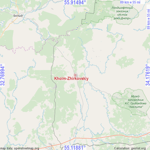
Kholm-Zhirkovskiy GPS coordinates[2]
55° 31' 8.004" North, 33° 28' 23.016" East
| Map corner | latitude | longitude |
|---|---|---|
| Upper-left | 55.91494°, | 32.76994° |
| Center: | 55.51889°, | 33.47306° |
| Lower-right: | 55.11881°, | 34.17619° |
| Map W x H: | 88.5×88.5 km | = 55×55mi |
| max Lat: | 73.50819° ⇑41.7% North |
| Kholm-Zhirkovskiy: | 55.51889° |
| min Lat: | ⇓58.3% South 41.28413° |
| min Long | Kholm-Zhirkovsk | max Long |
| -179.12198° | 33.47306° | 179.35046° |
| W 8.7%⇐ | ⇒91.3% E |
Elevation
Elevation of Kholm-Zhirkovskiy is 226 m = 741 ft, and this is 23.4 m = 77 ft above average elevation for this country.
| Max E: |
2518 m = 8261 ft | 23.1% |
| Kholm-Zhirkovskiy | 226 m 741 ft | |
| Avg. | 202.6 m = 665 ft | |
Min E: |
-28 m = -92 ft | 76.9% |
See also: Russia elevation on elevation.city.
Geographical zone
Kholm-Zhirkovskiy is located in North temperate zone (between Tropic of Cancer and the Arctic Circle). Distance of this North polar circle is 1228.1 km =763.1 mi to North.| Distance of | km | miles | from Kholm-Zhirkovskiy |
|---|---|---|---|
| North Pole | 3833.9 | 2382.3 | to North |
| Arctic Circle | 1228.1 | 763.1 | to North |
| Tropic Cancer | 3567.2 | 2216.6 | to South |
| Equator | 6173.1 | 3835.8 | to South |


Nearby cities:
15 places around Kholm-Zhirkovskiy: (largest is in red/bold)
• Belyy
48.8 km =30.3 mi,  317°
317°
• Dorogobuzh
68.1 km =42.3 mi,  189°
189°
• Dukhovshchina
76.3 km =47.4 mi,  241°
241°
• Gagarin
95.9 km =59.6 mi,  87°
87°
• Kardymovo
96.2 km =59.8 mi,  223°
223°
• Nelidovo
89.3 km =55.5 mi,  330°
330°
• Novodugino
52.5 km =32.6 mi,  76°
76°
• Olenino
76.8 km =47.7 mi,  0°
0°
• Ozërnyy
67 km =41.6 mi,  275°
275°
• Safonovo
47.8 km =29.7 mi,  198°
198°
• Sychëvka
60.7 km =37.7 mi,  55°
55°
• Verkhnedneprovskiy
60.3 km =37.5 mi, 187°
• Vyaz’ma
62.3 km =38.7 mi,  123°
123°
• Yartsevo
70.3 km =43.7 mi, 224°
• Zharkovskiy
83.9 km =52.1 mi,  295°
295°
Sources, notices
• [Note1] Compared only with cities in Russia existing in our database
• [Src1] Map data: © OpenStreetMap contributors (CC-BY-SA)
• [Src2] Other city data from geonames.org with taken over terms of usage.
• [Src3] Geographical zone / Annual Mean Temperature by Robert A. Rohde @ Wikipedia
