Bataysk geodata
Bataysk (Rostov) is a populated place; located in Russia in Europe/Moscow (GMT+3) time zone. With population of 109,962 people, there are 183 cities with bigger population in this country. Compared to other cities in Russia, 82.1% of cities are located further ↑North; 68.8% of cities are located further →East and 97.1% of cities have higher elevation than Bataysk. Note1


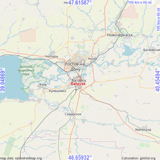
Bataysk GPS coordinates[2]
47° 8' 23.1" North, 39° 45' 6.516" East
| Map corner | latitude | longitude |
|---|---|---|
| Upper-left | 47.61587°, | 39.04869° |
| Center: | 47.13975°, | 39.75181° |
| Lower-right: | 46.65932°, | 40.45494° |
| Map W x H: | 106.4×106.4 km | = 66.1×66.1mi |
| max Lat: | 73.50819° ⇑82.1% North |
| Bataysk: | 47.13975° |
| min Lat: | ⇓17.9% South 41.28413° |
| min Long | Bataysk | max Long |
| -179.12198° | 39.75181° | 179.35046° |
| W 31.2%⇐ | ⇒68.8% E |
Elevation
Elevation of Bataysk is 7 m = 23 ft, and this is 195.6 m = 642 ft below average elevation for this country.
| Max E: |
2518 m = 8261 ft | 97.1% |
| Avg. | 202.6 m = 665 ft | |
| Bataysk | 7 m = 23 ft | |
Min E: |
-28 m = -92 ft | 2.9% |
See also: Bataysk elevation on elevation.city.
Geographical zone
Bataysk is located in North temperate zone (between Tropic of Cancer and the Arctic Circle). Distance of this North polar circle is 2159.7 km =1342 mi to North.| Distance of | km | miles | from Bataysk |
|---|---|---|---|
| North Pole | 4765.6 | 2961.2 | to North |
| Arctic Circle | 2159.7 | 1342 | to North |
| Tropic Cancer | 2635.5 | 1637.6 | to South |
| Equator | 5241.4 | 3256.9 | to South |


Nearby cities:
15 places around Bataysk: (largest is in red/bold)
• Aksay
15.8 km =9.8 mi,  33°
33°
• Azov
25.6 km =15.9 mi,  262°
262°
• Chaltyr
26 km =16.2 mi,  308°
308°
• Imeni Chkalova
15.8 km =9.8 mi,  359°
359°
• Kalinin
21.7 km =13.5 mi,  303°
303°
• Kirovskaya
28.5 km =17.7 mi,  130°
130°
• Krym
25.2 km =15.7 mi,  315°
315°
• Kuleshovka
16.2 km =10.1 mi,  244°
244°
• Novobataysk
27 km =16.8 mi,  175°
175°
• Ol’ginskaya
15.9 km =9.9 mi,  70°
70°
• Rostov-na-Donu
10.4 km =6.5 mi,  348°
348°
• Samarskoye
23.1 km =14.4 mi,  192°
192°
• Severnyy
16.9 km =10.5 mi, 349°
• Starocherkasskaya
24.6 km =15.3 mi,  62°
62°
• Verkhnetemernitzkiy
19.1 km =11.9 mi, 356°
Sources, notices
• [Note1] Compared only with cities in Russia existing in our database
• [Src1] Map data: © OpenStreetMap contributors (CC-BY-SA)
• [Src2] Other city data from geonames.org with taken over terms of usage.
• [Src3] Geographical zone / Annual Mean Temperature by Robert A. Rohde @ Wikipedia
