Sakmara geodata
Sakmara (Orenburg Oblast) is a populated place; located in Russia in Asia/Yekaterinburg (GMT+5) time zone. With population of 4,594 people, there are 2826 cities with bigger population in this country. Compared to other cities in Russia, 69.3% of cities are located further ↑North; 66.7% of cities are located further ←West and 66% of cities have higher elevation than Sakmara. Note1


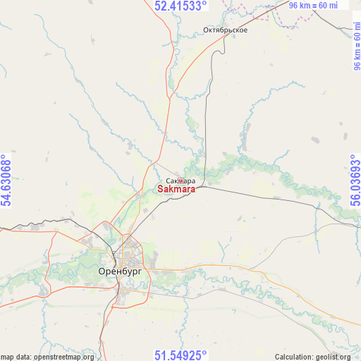
Sakmara GPS coordinates[2]
51° 59' 3.768" North, 55° 20' 1.68" East
| Map corner | latitude | longitude |
|---|---|---|
| Upper-left | 52.41533°, | 54.63068° |
| Center: | 51.98438°, | 55.3338° |
| Lower-right: | 51.54925°, | 56.03693° |
| Map W x H: | 96.3×96.3 km | = 59.8×59.8mi |
| max Lat: | 73.50819° ⇑69.3% North |
| Sakmara: | 51.98438° |
| min Lat: | ⇓30.7% South 41.28413° |
| min Long | Sakmara | max Long |
| -179.12198° | 55.3338° | 179.35046° |
| W 66.7%⇐ | ⇒33.3% E |
Elevation
Elevation of Sakmara is 111 m = 364 ft, and this is 91.6 m = 301 ft below average elevation for this country.
| Max E: |
2518 m = 8261 ft | 66% |
| Avg. | 202.6 m = 665 ft | |
| Sakmara | 111 m = 364 ft | |
Min E: |
-28 m = -92 ft | 34% |
See also: Russia elevation on elevation.city.
Geographical zone
Sakmara is located in North temperate zone (between Tropic of Cancer and the Arctic Circle). Distance of this North polar circle is 1621.1 km =1007.3 mi to North.| Distance of | km | miles | from Sakmara |
|---|---|---|---|
| North Pole | 4226.9 | 2626.5 | to North |
| Arctic Circle | 1621.1 | 1007.3 | to North |
| Tropic Cancer | 3174.2 | 1972.4 | to South |
| Equator | 5780.1 | 3591.6 | to South |


Nearby cities:
15 places around Sakmara: (largest is in red/bold)
• Isyangulovo
88.1 km =54.7 mi,  75°
75°
• Krasnokholm
91.7 km =57 mi,  242°
242°
• Krasnyy Kommunar
3.2 km =2 mi,  134°
134°
• Matveyevka
60.9 km =37.8 mi,  72°
72°
• Mayachnyy
81.4 km =50.6 mi,  17°
17°
• Nezhinka
24.2 km =15 mi,  174°
174°
• Nizhnepavlovka
47.4 km =29.5 mi,  230°
230°
• Orenburg
28.5 km =17.7 mi,  214°
214°
• Perevolotskiy
79.1 km =49.2 mi,  261°
261°
• Podgorodnyaya Pokrovka
29.4 km =18.3 mi, 233°
• Prigorodnyy
24.7 km =15.3 mi,  190°
190°
• Saraktash
73.8 km =45.9 mi,  107°
107°
• Tatarskaya Kargala
11.7 km =7.3 mi,  250°
250°
• Tyul’gan
69.2 km =43 mi,  55°
55°
• Yermolayevo
87.4 km =54.3 mi, 21°
Sources, notices
• [Note1] Compared only with cities in Russia existing in our database
• [Src1] Map data: © OpenStreetMap contributors (CC-BY-SA)
• [Src2] Other city data from geonames.org with taken over terms of usage.
• [Src3] Geographical zone / Annual Mean Temperature by Robert A. Rohde @ Wikipedia
