Sarmakovo geodata
Sarmakovo (Kabardino-Balkariya Republic) is a populated place; located in Russia in Europe/Moscow (GMT+3) time zone. With population of 9,588 people, there are 1572 cities with bigger population in this country. Compared to other cities in Russia, 92.8% of cities are located further ↑North; 55.8% of cities are located further →East and 95.8% of cities have lower elevation than Sarmakovo. Note1


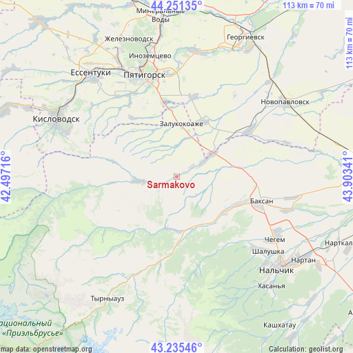
Sarmakovo GPS coordinates[2]
43° 44' 44.016" North, 43° 12' 1.008" East
| Map corner | latitude | longitude |
|---|---|---|
| Upper-left | 44.25135°, | 42.49716° |
| Center: | 43.74556°, | 43.20028° |
| Lower-right: | 43.23546°, | 43.90341° |
| Map W x H: | 113×113 km | = 70.2×70.2mi |
| max Lat: | 73.50819° ⇑92.8% North |
| Sarmakovo: | 43.74556° |
| min Lat: | ⇓7.2% South 41.28413° |
| min Long | Sarmakovo | max Long |
| -179.12198° | 43.20028° | 179.35046° |
| W 44.2%⇐ | ⇒55.8% E |
Elevation
Elevation of Sarmakovo is 686 m = 2251 ft, and this is 483.4 m = 1586 ft above average elevation for this country.
| Max E: |
2518 m = 8261 ft | 4.2% |
| Sarmakovo | 686 m 2251 ft | |
| Avg. | 202.6 m = 665 ft | |
Min E: |
-28 m = -92 ft | 95.8% |
See also: Russia elevation on elevation.city.
Geographical zone
Sarmakovo is located in North temperate zone (between Tropic of Cancer and the Arctic Circle). Distance of this Northern Tropic circle is 2258.1 km =1403.1 mi to South.| Distance of | km | miles | from Sarmakovo |
|---|---|---|---|
| North Pole | 5143 | 3195.7 | to North |
| Arctic Circle | 2537.1 | 1576.5 | to North |
| Tropic Cancer | 2258.1 | 1403.1 | to South |
| Equator | 4864.1 | 3022.4 | to South |


Nearby cities:
15 places around Sarmakovo: (largest is in red/bold)
• Etoka
22.9 km =14.2 mi,  327°
327°
• Gundelen
16.6 km =10.3 mi,  187°
187°
• Islamey
21.9 km =13.6 mi,  110°
110°
• Kamennomostskoye
12 km =7.5 mi,  265°
265°
• Kuba-Taba
19.8 km =12.3 mi,  80°
80°
• Kyzburun Pervyy
18.8 km =11.7 mi,  123°
123°
• Lashkuta
21.7 km =13.5 mi,  180°
180°
• Lechinkay
27.5 km =17.1 mi,  137°
137°
• Malka
11.9 km =7.4 mi,  56°
56°
• Nizhniy Kurkuzhin
12 km =7.5 mi,  88°
88°
• Pyatigorskiy
25.8 km =16 mi,  10°
10°
• Verkhniy Kurkuzhin
8.2 km =5.1 mi,  132°
132°
• Zalukokoazhe
17.6 km =10.9 mi,  3°
3°
• Zayukovo
18 km =11.2 mi, 143°
• Zhankhoteko
20.2 km =12.6 mi, 177°
Sources, notices
• [Note1] Compared only with cities in Russia existing in our database
• [Src1] Map data: © OpenStreetMap contributors (CC-BY-SA)
• [Src2] Other city data from geonames.org with taken over terms of usage.
• [Src3] Geographical zone / Annual Mean Temperature by Robert A. Rohde @ Wikipedia
