Kuba-Taba geodata
Kuba-Taba (Kabardino-Balkariya Republic) is a populated place; located in Russia in Europe/Moscow (GMT+3) time zone. With population of 3,179 people, there are 3624 cities with bigger population in this country. Compared to other cities in Russia, 92.7% of cities are located further ↑North; 54.9% of cities are located further →East and 90.7% of cities have lower elevation than Kuba-Taba. Note1


Kuba-Taba GPS coordinates[2]
43° 46' 33.996" North, 43° 26' 34.008" East
| Map corner | latitude | longitude |
|---|---|---|
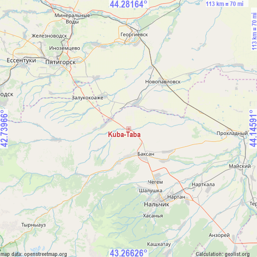
| Upper-left | 44.28164°, | 42.73966° |
| Center: | 43.77611°, | 43.44278° |
| Lower-right: | 43.26626°, | 44.14591° |
| Map W x H: | 112.9×112.9 km | = 70.2×70.2mi |
| max Lat: | 73.50819° ⇑92.7% North |
| Kuba-Taba: | 43.77611° |
| min Lat: | ⇓7.3% South 41.28413° |
| min Long | Kuba-Taba | max Long |
| -179.12198° | 43.44278° | 179.35046° |
| W 45.1%⇐ | ⇒54.9% E |
Elevation
Elevation of Kuba-Taba is 471 m = 1545 ft, and this is 268.4 m = 881 ft above average elevation for this country.
| Max E: |
2518 m = 8261 ft | 9.3% |
| Kuba-Taba | 471 m 1545 ft | |
| Avg. | 202.6 m = 665 ft | |
Min E: |
-28 m = -92 ft | 90.7% |
See also: Russia elevation on elevation.city.
Geographical zone
Kuba-Taba is located in North temperate zone (between Tropic of Cancer and the Arctic Circle). Distance of this Northern Tropic circle is 2261.5 km =1405.2 mi to South.| Distance of | km | miles | from Kuba-Taba |
|---|---|---|---|
| North Pole | 5139.6 | 3193.6 | to North |
| Arctic Circle | 2533.7 | 1574.4 | to North |
| Tropic Cancer | 2261.5 | 1405.2 | to South |
| Equator | 4867.4 | 3024.5 | to South |


Nearby cities:
15 places around Kuba-Taba: (largest is in red/bold)
• Baksan
12.4 km =7.7 mi,  142°
142°
• Baksanenok
19.6 km =12.2 mi,  119°
119°
• Chegem Vtoroy
23.7 km =14.7 mi,  147°
147°
• Dugulubgey
14.7 km =9.1 mi, 149°
• Islamey
11.2 km =7 mi,  174°
174°
• Kishpek
20.8 km =12.9 mi,  130°
130°
• Kyzburun Pervyy
14.4 km =8.9 mi,  195°
195°
• Lechinkay
23.5 km =14.6 mi,  181°
181°
• Malka
10 km =6.2 mi,  287°
287°
• Nizhniy Kurkuzhin
8.1 km =5 mi,  247°
247°
• Sarmakovo
19.8 km =12.3 mi,  260°
260°
• Staropavlovskaya
17.3 km =10.7 mi,  62°
62°
• Verkhniy Kurkuzhin
16.2 km =10.1 mi,  236°
236°
• Zalukokoazhe
23.1 km =14.4 mi,  307°
307°
• Zayukovo
19.8 km =12.3 mi,  206°
206°
Sources, notices
• [Note1] Compared only with cities in Russia existing in our database
• [Src1] Map data: © OpenStreetMap contributors (CC-BY-SA)
• [Src2] Other city data from geonames.org with taken over terms of usage.
• [Src3] Geographical zone / Annual Mean Temperature by Robert A. Rohde @ Wikipedia
