Malka geodata
Malka (Kabardino-Balkariya Republic) is a populated place; located in Russia in Europe/Moscow (GMT+3) time zone. With population of 7,220 people, there are 1948 cities with bigger population in this country. Compared to other cities in Russia, 92.6% of cities are located further ↑North; 55.3% of cities are located further →East and 93.7% of cities have lower elevation than Malka. Note1


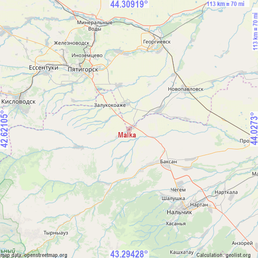
Malka GPS coordinates[2]
43° 48' 14.004" North, 43° 19' 27.012" East
| Map corner | latitude | longitude |
|---|---|---|
| Upper-left | 44.30919°, | 42.62105° |
| Center: | 43.80389°, | 43.32417° |
| Lower-right: | 43.29428°, | 44.0273° |
| Map W x H: | 112.8×112.8 km | = 70.1×70.1mi |
| max Lat: | 73.50819° ⇑92.6% North |
| Malka: | 43.80389° |
| min Lat: | ⇓7.4% South 41.28413° |
| min Long | Malka | max Long |
| -179.12198° | 43.32417° | 179.35046° |
| W 44.7%⇐ | ⇒55.3% E |
Elevation
Elevation of Malka is 570 m = 1870 ft, and this is 367.4 m = 1205 ft above average elevation for this country.
| Max E: |
2518 m = 8261 ft | 6.3% |
| Malka | 570 m 1870 ft | |
| Avg. | 202.6 m = 665 ft | |
Min E: |
-28 m = -92 ft | 93.7% |
See also: Russia elevation on elevation.city.
Geographical zone
Malka is located in North temperate zone (between Tropic of Cancer and the Arctic Circle). Distance of this Northern Tropic circle is 2264.6 km =1407.2 mi to South.| Distance of | km | miles | from Malka |
|---|---|---|---|
| North Pole | 5136.5 | 3191.7 | to North |
| Arctic Circle | 2530.6 | 1572.4 | to North |
| Tropic Cancer | 2264.6 | 1407.2 | to South |
| Equator | 4870.5 | 3026.4 | to South |


Nearby cities:
15 places around Malka: (largest is in red/bold)
• Baksan
21.4 km =13.3 mi,  127°
127°
• Dugulubgey
23.2 km =14.4 mi, 132°
• Etoka
25.6 km =15.9 mi,  300°
300°
• Gundelen
26 km =16.2 mi,  208°
208°
• Islamey
17.7 km =11 mi,  143°
143°
• Kamennomostskoye
23.1 km =14.4 mi,  251°
251°
• Kuba-Taba
10 km =6.2 mi,  107°
107°
• Kyzburun Pervyy
17.9 km =11.1 mi,  161°
161°
• Nizhniy Kurkuzhin
6.5 km =4 mi, 161°
• Pyatigorskiy
19.7 km =12.2 mi,  344°
344°
• Sarmakovo
11.9 km =7.4 mi,  236°
236°
• Staropavlovskaya
25.3 km =15.7 mi,  78°
78°
• Verkhniy Kurkuzhin
12.7 km =7.9 mi,  198°
198°
• Zalukokoazhe
14.1 km =8.8 mi,  321°
321°
• Zayukovo
20.9 km =13 mi,  177°
177°
Sources, notices
• [Note1] Compared only with cities in Russia existing in our database
• [Src1] Map data: © OpenStreetMap contributors (CC-BY-SA)
• [Src2] Other city data from geonames.org with taken over terms of usage.
• [Src3] Geographical zone / Annual Mean Temperature by Robert A. Rohde @ Wikipedia
