Saratovskaya geodata
Saratovskaya (Krasnodarskiy) is a populated place; located in Russia in Europe/Moscow (GMT+3) time zone. With population of 6,117 people, there are 2226 cities with bigger population in this country. Compared to other cities in Russia, 88.8% of cities are located further ↑North; 71.1% of cities are located further →East and 85.1% of cities have higher elevation than Saratovskaya. Note1


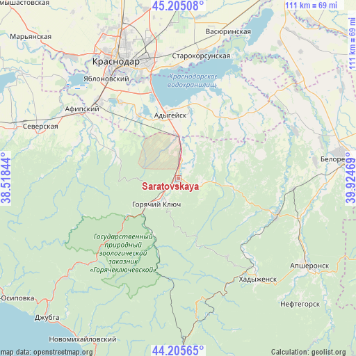
Saratovskaya GPS coordinates[2]
44° 42' 27.072" North, 39° 13' 17.616" East
| Map corner | latitude | longitude |
|---|---|---|
| Upper-left | 45.20508°, | 38.51844° |
| Center: | 44.70752°, | 39.22156° |
| Lower-right: | 44.20565°, | 39.92469° |
| Map W x H: | 111.1×111.1 km | = 69×69mi |
| max Lat: | 73.50819° ⇑88.8% North |
| Saratovskaya: | 44.70752° |
| min Lat: | ⇓11.2% South 41.28413° |
| min Long | Saratovskaya | max Long |
| -179.12198° | 39.22156° | 179.35046° |
| W 28.9%⇐ | ⇒71.1% E |
Elevation
Elevation of Saratovskaya is 47 m = 154 ft, and this is 155.6 m = 510 ft below average elevation for this country.
| Max E: |
2518 m = 8261 ft | 85.1% |
| Avg. | 202.6 m = 665 ft | |
| Saratovskaya | 47 m = 154 ft | |
Min E: |
-28 m = -92 ft | 14.9% |
See also: Russia elevation on elevation.city.
Geographical zone
Saratovskaya is located in North temperate zone (between Tropic of Cancer and the Arctic Circle). Distance of this Northern Tropic circle is 2365.1 km =1469.6 mi to South.| Distance of | km | miles | from Saratovskaya |
|---|---|---|---|
| North Pole | 5036.1 | 3129.3 | to North |
| Arctic Circle | 2430.2 | 1510.1 | to North |
| Tropic Cancer | 2365.1 | 1469.6 | to South |
| Equator | 4971 | 3088.8 | to South |


Nearby cities:
15 places around Saratovskaya: (largest is in red/bold)
• Adygeysk
19.8 km =12.3 mi,  352°
352°
• Afipskiy
36.8 km =22.9 mi,  305°
305°
• Enem
34.8 km =21.6 mi, 314°
• Goryachiy Klyuch
11.2 km =7 mi,  220°
220°
• Khadyzhensk
40 km =24.9 mi,  141°
141°
• Krasnodar
42.2 km =26.2 mi,  332°
332°
• Novodmitriyevskaya
30.5 km =19 mi,  297°
297°
• Pashkovskiy
36.3 km =22.6 mi, 345°
• Ponezhukay
23.8 km =14.8 mi,  32°
32°
• Ryazanskaya
40 km =24.9 mi,  46°
46°
• Smolenskaya
34.2 km =21.3 mi,  284°
284°
• Starokorsunskaya
39.6 km =24.6 mi,  10°
10°
• Takhtamukay
29.7 km =18.5 mi,  323°
323°
• Tlyustenkhabl’
32 km =19.9 mi,  342°
342°
• Yablonovskiy
38.2 km =23.7 mi, 324°
Sources, notices
• [Note1] Compared only with cities in Russia existing in our database
• [Src1] Map data: © OpenStreetMap contributors (CC-BY-SA)
• [Src2] Other city data from geonames.org with taken over terms of usage.
• [Src3] Geographical zone / Annual Mean Temperature by Robert A. Rohde @ Wikipedia
