Nezhinka geodata
Nezhinka (Orenburg Oblast) is a populated place; located in Russia in Asia/Yekaterinburg (GMT+5) time zone. With population of 5,100 people, there are 2611 cities with bigger population in this country. Compared to other cities in Russia, 70.6% of cities are located further ↑North; 66.8% of cities are located further ←West and 71% of cities have higher elevation than Nezhinka. Note1


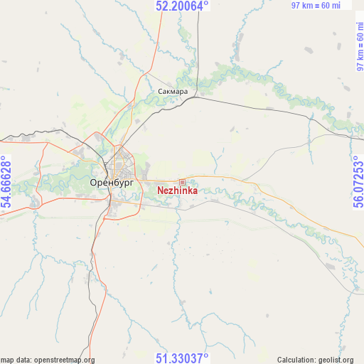
Nezhinka GPS coordinates[2]
51° 46' 3.36" North, 55° 22' 9.84" East
| Map corner | latitude | longitude |
|---|---|---|
| Upper-left | 52.20064°, | 54.66628° |
| Center: | 51.7676°, | 55.3694° |
| Lower-right: | 51.33037°, | 56.07253° |
| Map W x H: | 96.8×96.8 km | = 60.1×60.1mi |
| max Lat: | 73.50819° ⇑70.6% North |
| Nezhinka: | 51.7676° |
| min Lat: | ⇓29.4% South 41.28413° |
| min Long | Nezhinka | max Long |
| -179.12198° | 55.3694° | 179.35046° |
| W 66.8%⇐ | ⇒33.2% E |
Elevation
Elevation of Nezhinka is 100 m = 328 ft, and this is 102.6 m = 337 ft below average elevation for this country.
| Max E: |
2518 m = 8261 ft | 71% |
| Avg. | 202.6 m = 665 ft | |
| Nezhinka | 100 m = 328 ft | |
Min E: |
-28 m = -92 ft | 29% |
See also: Russia elevation on elevation.city.
Geographical zone
Nezhinka is located in North temperate zone (between Tropic of Cancer and the Arctic Circle). Distance of this North polar circle is 1645.2 km =1022.3 mi to North.| Distance of | km | miles | from Nezhinka |
|---|---|---|---|
| North Pole | 4251 | 2641.4 | to North |
| Arctic Circle | 1645.2 | 1022.3 | to North |
| Tropic Cancer | 3150.1 | 1957.4 | to South |
| Equator | 5756 | 3576.6 | to South |


Nearby cities:
15 places around Nezhinka: (largest is in red/bold)
• Belyayevka
83.2 km =51.7 mi,  119°
119°
• Dubenskiy
94 km =58.4 mi,  111°
111°
• Krasnokholm
85.7 km =53.3 mi,  257°
257°
• Krasnyy Kommunar
21.9 km =13.6 mi,  359°
359°
• Matveyevka
70.1 km =43.6 mi,  52°
52°
• Nizhnepavlovka
39.6 km =24.6 mi, 261°
• Orenburg
18.6 km =11.6 mi,  271°
271°
• Perevolotskiy
81.7 km =50.8 mi,  278°
278°
• Podgorodnyaya Pokrovka
27.1 km =16.8 mi, 284°
• Prigorodnyy
7.1 km =4.4 mi, 268°
• Sakmara
24.2 km =15 mi,  354°
354°
• Saraktash
68.2 km =42.4 mi,  88°
88°
• Sol’-Iletsk
72.1 km =44.8 mi,  201°
201°
• Tatarskaya Kargala
24.3 km =15.1 mi,  326°
326°
• Tyul’gan
83.8 km =52.1 mi,  40°
40°
Sources, notices
• [Note1] Compared only with cities in Russia existing in our database
• [Src1] Map data: © OpenStreetMap contributors (CC-BY-SA)
• [Src2] Other city data from geonames.org with taken over terms of usage.
• [Src3] Geographical zone / Annual Mean Temperature by Robert A. Rohde @ Wikipedia
