Perevolotskiy geodata
Perevolotskiy (Orenburg Oblast) is a populated place; located in Russia in Asia/Yekaterinburg (GMT+5) time zone. With population of 9,667 people, there are 1557 cities with bigger population in this country. Compared to other cities in Russia, 69.9% of cities are located further ↑North; 65.9% of cities are located further ←West and 63.8% of cities have lower elevation than Perevolotskiy. Note1


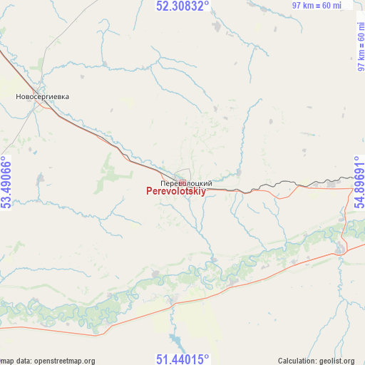
Perevolotskiy GPS coordinates[2]
51° 52' 34.788" North, 54° 11' 37.608" East
| Map corner | latitude | longitude |
|---|---|---|
| Upper-left | 52.30832°, | 53.49066° |
| Center: | 51.87633°, | 54.19378° |
| Lower-right: | 51.44015°, | 54.89691° |
| Map W x H: | 96.5×96.5 km | = 60×60mi |
| max Lat: | 73.50819° ⇑69.9% North |
| Perevolotskiy: | 51.87633° |
| min Lat: | ⇓30.1% South 41.28413° |
| min Long | Perevolotskiy | max Long |
| -179.12198° | 54.19378° | 179.35046° |
| W 65.9%⇐ | ⇒34.1% E |
Elevation
Elevation of Perevolotskiy is 179 m = 587 ft, and this is 23.6 m = 77 ft below average elevation for this country.
| Max E: |
2518 m = 8261 ft | 36.2% |
| Avg. | 202.6 m = 665 ft | |
| Perevolotskiy | 179 m = 587 ft | |
Min E: |
-28 m = -92 ft | 63.8% |
See also: Russia elevation on elevation.city.
Geographical zone
Perevolotskiy is located in North temperate zone (between Tropic of Cancer and the Arctic Circle). Distance of this North polar circle is 1633.1 km =1014.8 mi to North.| Distance of | km | miles | from Perevolotskiy |
|---|---|---|---|
| North Pole | 4239 | 2634 | to North |
| Arctic Circle | 1633.1 | 1014.8 | to North |
| Tropic Cancer | 3162.2 | 1964.9 | to South |
| Equator | 5768.1 | 3584.1 | to South |


Nearby cities:
15 places around Perevolotskiy: (largest is in red/bold)
• Ilek
68 km =42.3 mi,  235°
235°
• Kardailovo
42.5 km =26.4 mi,  207°
207°
• Krasnokholm
31.1 km =19.3 mi,  184°
184°
• Krasnyy Kommunar
81 km =50.3 mi,  83°
83°
• Nezhinka
81.7 km =50.8 mi,  98°
98°
• Nizhnepavlovka
45.6 km =28.3 mi,  113°
113°
• Novosergiyevka
44.2 km =27.5 mi,  303°
303°
• Orenburg
63.3 km =39.3 mi, 100°
• Podgorodnyaya Pokrovka
54.8 km =34.1 mi, 95°
• Prigorodnyy
74.7 km =46.4 mi, 99°
• Sakmara
79.1 km =49.2 mi, 81°
• Sol’-Iletsk
96.6 km =60 mi,  145°
145°
• Sorochinsk
94 km =58.4 mi,  311°
311°
• Tashla
100.4 km =62.4 mi,  263°
263°
• Tatarskaya Kargala
67.7 km =42.1 mi, 83°
Sources, notices
• [Note1] Compared only with cities in Russia existing in our database
• [Src1] Map data: © OpenStreetMap contributors (CC-BY-SA)
• [Src2] Other city data from geonames.org with taken over terms of usage.
• [Src3] Geographical zone / Annual Mean Temperature by Robert A. Rohde @ Wikipedia
