Isyangulovo geodata
Isyangulovo (Bashkortostan Republic) is a populated place; located in Russia in Asia/Yekaterinburg (GMT+5) time zone. With population of 7,455 people, there are 1908 cities with bigger population in this country. Compared to other cities in Russia, 68.1% of cities are located further ↑North; 68.2% of cities are located further ←West and 65.9% of cities have lower elevation than Isyangulovo. Note1


Isyangulovo GPS coordinates[2]
52° 11' 9.024" North, 56° 34' 49.548" East
| Map corner | latitude | longitude |
|---|---|---|
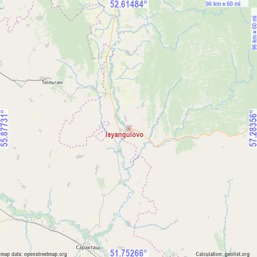
| Upper-left | 52.61484°, | 55.87731° |
| Center: | 52.18584°, | 56.58043° |
| Lower-right: | 51.75266°, | 57.28356° |
| Map W x H: | 95.9×95.9 km | = 59.6×59.6mi |
| max Lat: | 73.50819° ⇑68.1% North |
| Isyangulovo: | 52.18584° |
| min Lat: | ⇓31.9% South 41.28413° |
| min Long | Isyangulovo | max Long |
| -179.12198° | 56.58043° | 179.35046° |
| W 68.2%⇐ | ⇒31.8% E |
Elevation
Elevation of Isyangulovo is 184 m = 604 ft, and this is 18.6 m = 61 ft below average elevation for this country.
| Max E: |
2518 m = 8261 ft | 34.1% |
| Avg. | 202.6 m = 665 ft | |
| Isyangulovo | 184 m = 604 ft | |
Min E: |
-28 m = -92 ft | 65.9% |
See also: Russia elevation on elevation.city.
Geographical zone
Isyangulovo is located in North temperate zone (between Tropic of Cancer and the Arctic Circle). Distance of this North polar circle is 1598.7 km =993.4 mi to North.| Distance of | km | miles | from Isyangulovo |
|---|---|---|---|
| North Pole | 4204.5 | 2612.6 | to North |
| Arctic Circle | 1598.7 | 993.4 | to North |
| Tropic Cancer | 3196.6 | 1986.3 | to South |
| Equator | 5802.5 | 3605.5 | to South |


Nearby cities:
15 places around Isyangulovo: (largest is in red/bold)
• Belyayevka
88.4 km =54.9 mi,  187°
187°
• Dubenskiy
81.4 km =50.6 mi,  177°
177°
• Krasnyy Kommunar
86.5 km =53.7 mi,  253°
253°
• Kumertau
84.2 km =52.3 mi,  320°
320°
• Kuvandyk
95 km =59 mi,  145°
145°
• Matveyevka
27.4 km =17 mi,  261°
261°
• Mayachnyy
82.2 km =51.1 mi,  312°
312°
• Mrakovo
59 km =36.7 mi,  2°
2°
• Nezhinka
95.1 km =59.1 mi,  240°
240°
• Sakmara
88.1 km =54.7 mi, 255°
• Saraktash
46.8 km =29.1 mi,  198°
198°
• Tyul’gan
33 km =20.5 mi,  301°
301°
• Yermolayevo
79.2 km =49.2 mi, 318°
• Yumaguzino
80.9 km =50.3 mi,  350°
350°
• Zilair
58.7 km =36.5 mi,  84°
84°
Sources, notices
• [Note1] Compared only with cities in Russia existing in our database
• [Src1] Map data: © OpenStreetMap contributors (CC-BY-SA)
• [Src2] Other city data from geonames.org with taken over terms of usage.
• [Src3] Geographical zone / Annual Mean Temperature by Robert A. Rohde @ Wikipedia
