Tyul’gan geodata
Tyul’gan (Orenburg Oblast) is a populated place; located in Russia in Asia/Yekaterinburg (GMT+5) time zone. With population of 10,200 people, there are 1479 cities with bigger population in this country. Compared to other cities in Russia, 67.1% of cities are located further ↑North; 67.7% of cities are located further ←West and 84.3% of cities have lower elevation than Tyul’gan. Note1


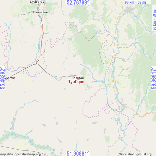
Tyul’gan GPS coordinates[2]
52° 20' 25.764" North, 56° 9' 57.744" East
| Map corner | latitude | longitude |
|---|---|---|
| Upper-left | 52.76799°, | 55.46292° |
| Center: | 52.34049°, | 56.16604° |
| Lower-right: | 51.90881°, | 56.86917° |
| Map W x H: | 95.5×95.5 km | = 59.3×59.3mi |
| max Lat: | 73.50819° ⇑67.1% North |
| Tyul’gan: | 52.34049° |
| min Lat: | ⇓32.9% South 41.28413° |
| min Long | Tyul’gan | max Long |
| -179.12198° | 56.16604° | 179.35046° |
| W 67.7%⇐ | ⇒32.3% E |
Elevation
Elevation of Tyul’gan is 308 m = 1010 ft, and this is 105.4 m = 346 ft above average elevation for this country.
| Max E: |
2518 m = 8261 ft | 15.7% |
| Tyul’gan | 308 m 1010 ft | |
| Avg. | 202.6 m = 665 ft | |
Min E: |
-28 m = -92 ft | 84.3% |
See also: Russia elevation on elevation.city.
Geographical zone
Tyul’gan is located in North temperate zone (between Tropic of Cancer and the Arctic Circle). Distance of this North polar circle is 1581.5 km =982.7 mi to North.| Distance of | km | miles | from Tyul’gan |
|---|---|---|---|
| North Pole | 4187.3 | 2601.9 | to North |
| Arctic Circle | 1581.5 | 982.7 | to North |
| Tropic Cancer | 3213.8 | 1997 | to South |
| Equator | 5819.7 | 3616.2 | to South |


Nearby cities:
15 places around Tyul’gan: (largest is in red/bold)
• Isyangulovo
33 km =20.5 mi,  121°
121°
• Krasnyy Kommunar
68.7 km =42.7 mi,  232°
232°
• Kumertau
54 km =33.6 mi,  331°
331°
• Matveyevka
21.2 km =13.2 mi,  176°
176°
• Mayachnyy
50.2 km =31.2 mi,  319°
319°
• Meleuz
71.2 km =44.2 mi,  347°
347°
• Mrakovo
52 km =32.3 mi,  36°
36°
• Nezhinka
83.8 km =52.1 mi,  220°
220°
• Sakmara
69.2 km =43 mi,  235°
235°
• Saraktash
62.9 km =39.1 mi,  167°
167°
• Tatarskaya Kargala
80.5 km =50 mi, 237°
• Voskresenskoye
87.1 km =54.1 mi,  359°
359°
• Yermolayevo
48.6 km =30.2 mi, 329°
• Yumaguzino
64.5 km =40.1 mi,  13°
13°
• Zilair
87.4 km =54.3 mi,  97°
97°
Sources, notices
• [Note1] Compared only with cities in Russia existing in our database
• [Src1] Map data: © OpenStreetMap contributors (CC-BY-SA)
• [Src2] Other city data from geonames.org with taken over terms of usage.
• [Src3] Geographical zone / Annual Mean Temperature by Robert A. Rohde @ Wikipedia
