Pugachev geodata
Pugachev (Saratovskaya Oblast) is a populated place; located in Russia in Europe/Saratov (GMT+4) time zone. With population of 41,375 people, there are 510 cities with bigger population in this country. Compared to other cities in Russia, 69.1% of cities are located further ↑North; 60.5% of cities are located further ←West and 87% of cities have higher elevation than Pugachev. Note1


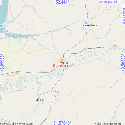
Pugachev GPS coordinates[2]
52° 0' 47.988" North, 48° 48' 9" East
| Map corner | latitude | longitude |
|---|---|---|
| Upper-left | 52.444°, | 48.09938° |
| Center: | 52.01333°, | 48.8025° |
| Lower-right: | 51.57848°, | 49.50563° |
| Map W x H: | 96.2×96.2 km | = 59.8×59.8mi |
| max Lat: | 73.50819° ⇑69.1% North |
| Pugachev: | 52.01333° |
| min Lat: | ⇓30.9% South 41.28413° |
| min Long | Pugachev | max Long |
| -179.12198° | 48.8025° | 179.35046° |
| W 60.5%⇐ | ⇒39.5% E |
Elevation
Elevation of Pugachev is 40 m = 131 ft, and this is 162.6 m = 533 ft below average elevation for this country.
| Max E: |
2518 m = 8261 ft | 87% |
| Avg. | 202.6 m = 665 ft | |
| Pugachev | 40 m = 131 ft | |
Min E: |
-28 m = -92 ft | 13% |
See also: Pugachev elevation on elevation.city.
Geographical zone
Pugachev is located in North temperate zone (between Tropic of Cancer and the Arctic Circle). Distance of this North polar circle is 1617.8 km =1005.3 mi to North.| Distance of | km | miles | from Pugachev |
|---|---|---|---|
| North Pole | 4223.7 | 2624.5 | to North |
| Arctic Circle | 1617.8 | 1005.3 | to North |
| Tropic Cancer | 3177.4 | 1974.3 | to South |
| Equator | 5783.3 | 3593.6 | to South |


Nearby cities:
15 places around Pugachev: (largest is in red/bold)
• Alekseyevka
62.1 km =38.6 mi,  301°
301°
• Balakovo
68.6 km =42.6 mi,  271°
271°
• Dergachi
86.8 km =53.9 mi,  181°
181°
• Dukhovnitskoye
65.8 km =40.9 mi,  322°
322°
• Gornyy
33.6 km =20.9 mi,  212°
212°
• Ivanteyevka
34.9 km =21.7 mi,  36°
36°
• Khvalynsk
71.2 km =44.2 mi, 318°
• Khvorostyanka
67.2 km =41.8 mi,  9°
9°
• Kormëzhka
55.3 km =34.4 mi,  256°
256°
• Mayskoye
88.8 km =55.2 mi,  71°
71°
• Osinki
104.1 km =64.7 mi,  27°
27°
• Pestravka
89.8 km =55.8 mi,  61°
61°
• Tersa
86.8 km =53.9 mi,  275°
275°
• Vol’sk
97.4 km =60.5 mi, 272°
• Yershov
82.1 km =51 mi, 206°
Sources, notices
• [Note1] Compared only with cities in Russia existing in our database
• [Src1] Map data: © OpenStreetMap contributors (CC-BY-SA)
• [Src2] Other city data from geonames.org with taken over terms of usage.
• [Src3] Geographical zone / Annual Mean Temperature by Robert A. Rohde @ Wikipedia
