Dukhovnitskoye geodata
Dukhovnitskoye (Saratovskaya Oblast) is a populated place; located in Russia in Europe/Saratov (GMT+4) time zone. With population of 5,943 people, there are 2275 cities with bigger population in this country. Compared to other cities in Russia, 66.3% of cities are located further ↑North; 59.4% of cities are located further ←West and 88.2% of cities have higher elevation than Dukhovnitskoye. Note1


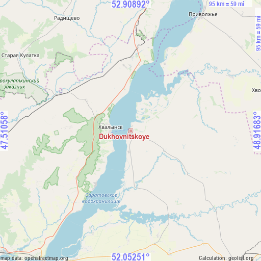
Dukhovnitskoye GPS coordinates[2]
52° 28' 58.08" North, 48° 12' 49.32" East
| Map corner | latitude | longitude |
|---|---|---|
| Upper-left | 52.90892°, | 47.51058° |
| Center: | 52.4828°, | 48.2137° |
| Lower-right: | 52.05251°, | 48.91683° |
| Map W x H: | 95.2×95.2 km | = 59.2×59.2mi |
| max Lat: | 73.50819° ⇑66.3% North |
| Dukhovnitskoye: | 52.4828° |
| min Lat: | ⇓33.7% South 41.28413° |
| min Long | Dukhovnitskoye | max Long |
| -179.12198° | 48.2137° | 179.35046° |
| W 59.4%⇐ | ⇒40.6% E |
Elevation
Elevation of Dukhovnitskoye is 35 m = 115 ft, and this is 167.6 m = 550 ft below average elevation for this country.
| Max E: |
2518 m = 8261 ft | 88.2% |
| Avg. | 202.6 m = 665 ft | |
| Dukhovnitskoye | 35 m = 115 ft | |
Min E: |
-28 m = -92 ft | 11.8% |
See also: Russia elevation on elevation.city.
Geographical zone
Dukhovnitskoye is located in North temperate zone (between Tropic of Cancer and the Arctic Circle). Distance of this North polar circle is 1565.6 km =972.8 mi to North.| Distance of | km | miles | from Dukhovnitskoye |
|---|---|---|---|
| North Pole | 4171.5 | 2592 | to North |
| Arctic Circle | 1565.6 | 972.8 | to North |
| Tropic Cancer | 3229.6 | 2006.8 | to South |
| Equator | 5835.5 | 3626 | to South |


Nearby cities:
15 places around Dukhovnitskoye: (largest is in red/bold)
• Alekseyevka
23.4 km =14.5 mi,  212°
212°
• Balakovo
57.9 km =36 mi, 209°
• Cherkasskoye
68.2 km =42.4 mi,  264°
264°
• Ivanteyevka
65.1 km =40.5 mi,  111°
111°
• Khvalynsk
7.4 km =4.6 mi,  276°
276°
• Khvorostyanka
52.4 km =32.6 mi,  74°
74°
• Kormëzhka
66.1 km =41.1 mi,  191°
191°
• Pavlovka
76.1 km =47.3 mi,  287°
287°
• Pugachev
65.8 km =40.9 mi,  142°
142°
• Radishchevo
47.2 km =29.3 mi,  331°
331°
• Staraya Kulatka
48.6 km =30.2 mi,  304°
304°
• Syzran’
77.1 km =47.9 mi,  12°
12°
• Tersa
63.6 km =39.5 mi,  226°
226°
• Varlamovo
79.8 km =49.6 mi, 10°
• Vol’sk
74.7 km =46.4 mi, 229°
Sources, notices
• [Note1] Compared only with cities in Russia existing in our database
• [Src1] Map data: © OpenStreetMap contributors (CC-BY-SA)
• [Src2] Other city data from geonames.org with taken over terms of usage.
• [Src3] Geographical zone / Annual Mean Temperature by Robert A. Rohde @ Wikipedia
