Khvorostyanka geodata
Khvorostyanka (Samara Oblast) is a populated place; located in Russia in Europe/Samara (GMT+4) time zone. With population of 4,899 people, there are 2709 cities with bigger population in this country. Compared to other cities in Russia, 65.4% of cities are located further ↑North; 60.7% of cities are located further ←West and 86% of cities have higher elevation than Khvorostyanka. Note1


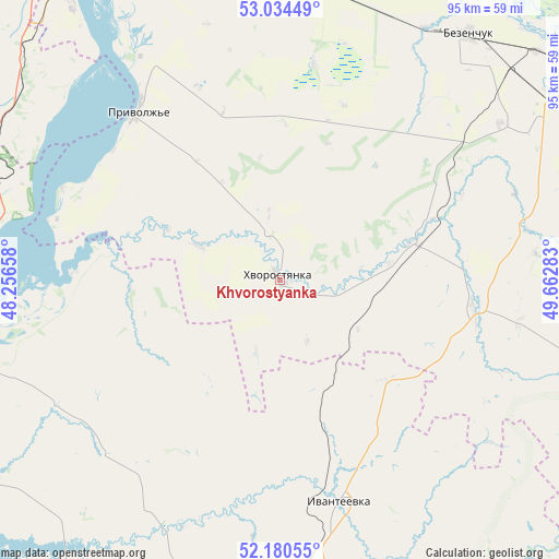
Khvorostyanka GPS coordinates[2]
52° 36' 34.56" North, 48° 57' 34.92" East
| Map corner | latitude | longitude |
|---|---|---|
| Upper-left | 53.03449°, | 48.25658° |
| Center: | 52.6096°, | 48.9597° |
| Lower-right: | 52.18055°, | 49.66283° |
| Map W x H: | 94.9×94.9 km | = 59×59mi |
| max Lat: | 73.50819° ⇑65.4% North |
| Khvorostyanka: | 52.6096° |
| min Lat: | ⇓34.6% South 41.28413° |
| min Long | Khvorostyanka | max Long |
| -179.12198° | 48.9597° | 179.35046° |
| W 60.7%⇐ | ⇒39.3% E |
Elevation
Elevation of Khvorostyanka is 43 m = 141 ft, and this is 159.6 m = 524 ft below average elevation for this country.
| Max E: |
2518 m = 8261 ft | 86% |
| Avg. | 202.6 m = 665 ft | |
| Khvorostyanka | 43 m = 141 ft | |
Min E: |
-28 m = -92 ft | 14% |
See also: Russia elevation on elevation.city.
Geographical zone
Khvorostyanka is located in North temperate zone (between Tropic of Cancer and the Arctic Circle). Distance of this North polar circle is 1551.5 km =964.1 mi to North.| Distance of | km | miles | from Khvorostyanka |
|---|---|---|---|
| North Pole | 4157.4 | 2583.3 | to North |
| Arctic Circle | 1551.5 | 964.1 | to North |
| Tropic Cancer | 3243.7 | 2015.5 | to South |
| Equator | 5849.6 | 3634.8 | to South |


Nearby cities:
15 places around Khvorostyanka: (largest is in red/bold)
• Alekseyevka
71.7 km =44.6 mi,  241°
241°
• Bezenchuk
52.2 km =32.4 mi,  37°
37°
• Chapayevsk
64.8 km =40.3 mi,  50°
50°
• Dukhovnitskoye
52.4 km =32.6 mi,  254°
254°
• Ivanteyevka
39.4 km =24.5 mi,  165°
165°
• Khvalynsk
59.2 km =36.8 mi,  257°
257°
• Krasnoarmeyskoye
73.3 km =45.5 mi,  80°
80°
• Mezhdurechensk
73.7 km =45.8 mi,  7°
7°
• Obsharovka
57.8 km =35.9 mi,  352°
352°
• Oktyabr’sk
64.4 km =40 mi,  344°
344°
• Osinki
45.4 km =28.2 mi,  55°
55°
• Perevoloki
72.3 km =44.9 mi, 11°
• Pestravka
71.7 km =44.6 mi,  109°
109°
• Pugachev
67.2 km =41.8 mi,  189°
189°
• Syzran’
69.4 km =43.1 mi,  331°
331°
Sources, notices
• [Note1] Compared only with cities in Russia existing in our database
• [Src1] Map data: © OpenStreetMap contributors (CC-BY-SA)
• [Src2] Other city data from geonames.org with taken over terms of usage.
• [Src3] Geographical zone / Annual Mean Temperature by Robert A. Rohde @ Wikipedia
