Ivanteyevka geodata
Ivanteyevka (Saratovskaya Oblast) is a populated place; located in Russia in Europe/Saratov (GMT+4) time zone. With population of 6,127 people, there are 2224 cities with bigger population in this country. Compared to other cities in Russia, 67.5% of cities are located further ↑North; 60.9% of cities are located further ←West and 84.4% of cities have higher elevation than Ivanteyevka. Note1


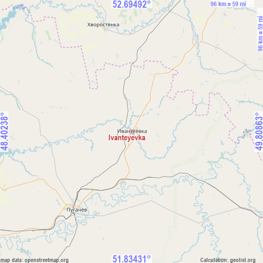
Ivanteyevka GPS coordinates[2]
52° 16' 0.12" North, 49° 6' 19.8" East
| Map corner | latitude | longitude |
|---|---|---|
| Upper-left | 52.69492°, | 48.40238° |
| Center: | 52.2667°, | 49.1055° |
| Lower-right: | 51.83431°, | 49.80863° |
| Map W x H: | 95.7×95.7 km | = 59.5×59.5mi |
| max Lat: | 73.50819° ⇑67.5% North |
| Ivanteyevka: | 52.2667° |
| min Lat: | ⇓32.5% South 41.28413° |
| min Long | Ivanteyevka | max Long |
| -179.12198° | 49.1055° | 179.35046° |
| W 60.9%⇐ | ⇒39.1% E |
Elevation
Elevation of Ivanteyevka is 50 m = 164 ft, and this is 152.6 m = 501 ft below average elevation for this country.
| Max E: |
2518 m = 8261 ft | 84.4% |
| Avg. | 202.6 m = 665 ft | |
| Ivanteyevka | 50 m = 164 ft | |
Min E: |
-28 m = -92 ft | 15.6% |
See also: Russia elevation on elevation.city.
Geographical zone
Ivanteyevka is located in North temperate zone (between Tropic of Cancer and the Arctic Circle). Distance of this North polar circle is 1589.7 km =987.8 mi to North.| Distance of | km | miles | from Ivanteyevka |
|---|---|---|---|
| North Pole | 4195.5 | 2607 | to North |
| Arctic Circle | 1589.7 | 987.8 | to North |
| Tropic Cancer | 3205.6 | 1991.9 | to South |
| Equator | 5811.5 | 3611.1 | to South |


Nearby cities:
15 places around Ivanteyevka: (largest is in red/bold)
• Alekseyevka
73.5 km =45.7 mi,  273°
273°
• Balakovo
92.9 km =57.7 mi,  253°
253°
• Bezenchuk
82.6 km =51.3 mi,  15°
15°
• Chapayevsk
88.9 km =55.2 mi,  27°
27°
• Dukhovnitskoye
65.1 km =40.5 mi,  291°
291°
• Gornyy
68.5 km =42.6 mi,  214°
214°
• Khvalynsk
72.3 km =44.9 mi, 290°
• Khvorostyanka
39.4 km =24.5 mi,  345°
345°
• Kormëzhka
84.8 km =52.7 mi,  241°
241°
• Krasnoarmeyskoye
80.4 km =50 mi,  51°
51°
• Mayskoye
63.2 km =39.3 mi,  89°
89°
• Osinki
69.8 km =43.4 mi, 23°
• Perelyub
96.4 km =59.9 mi,  117°
117°
• Pestravka
59.9 km =37.2 mi,  75°
75°
• Pugachev
34.9 km =21.7 mi,  216°
216°
Sources, notices
• [Note1] Compared only with cities in Russia existing in our database
• [Src1] Map data: © OpenStreetMap contributors (CC-BY-SA)
• [Src2] Other city data from geonames.org with taken over terms of usage.
• [Src3] Geographical zone / Annual Mean Temperature by Robert A. Rohde @ Wikipedia
