Povenets geodata
Povenets (Karelia) is a populated place; located in Russia in Europe/Moscow (GMT+3) time zone. With population of 2,539 people, there are 3940 cities with bigger population in this country. Compared to other cities in Russia, 96% of cities are located further ↓South; 89.2% of cities are located further →East and 87% of cities have higher elevation than Povenets. Note1


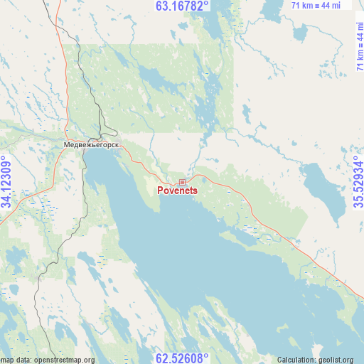
Povenets GPS coordinates[2]
62° 50' 55.32" North, 34° 49' 34.356" East
| Map corner | latitude | longitude |
|---|---|---|
| Upper-left | 63.16782°, | 34.12309° |
| Center: | 62.8487°, | 34.82621° |
| Lower-right: | 62.52608°, | 35.52934° |
| Map W x H: | 71.4×71.4 km | = 44.4×44.4mi |
| max Lat: | 73.50819° ⇑4% North |
| Povenets: | 62.8487° |
| min Lat: | ⇓96% South 41.28413° |
| min Long | Povenets | max Long |
| -179.12198° | 34.82621° | 179.35046° |
| W 10.8%⇐ | ⇒89.2% E |
Elevation
Elevation of Povenets is 40 m = 131 ft, and this is 162.6 m = 533 ft below average elevation for this country.
| Max E: |
2518 m = 8261 ft | 87% |
| Avg. | 202.6 m = 665 ft | |
| Povenets | 40 m = 131 ft | |
Min E: |
-28 m = -92 ft | 13% |
See also: Russia elevation on elevation.city.
Geographical zone
Povenets is located in North temperate zone (between Tropic of Cancer and the Arctic Circle). Distance of this North polar circle is 413.1 km =256.7 mi to North.| Distance of | km | miles | from Povenets |
|---|---|---|---|
| North Pole | 3018.9 | 1875.9 | to North |
| Arctic Circle | 413.1 | 256.7 | to North |
| Tropic Cancer | 4382.2 | 2723 | to South |
| Equator | 6988.1 | 4342.2 | to South |


Nearby cities:
15 places around Povenets: (largest is in red/bold)
• Gimoly
128.7 km =80 mi,  279°
279°
• Girvas
71.3 km =44.3 mi,  234°
234°
• Kondopoga
77.1 km =47.9 mi,  202°
202°
• Matrosy
129.8 km =80.7 mi, 203°
• Medvezh’yegorsk
20.2 km =12.6 mi,  292°
292°
• Nadvoitsy
116 km =72.1 mi,  347°
347°
• Petrozavodsk
120.8 km =75.1 mi,  191°
191°
• Pindushi
14.5 km =9 mi,  300°
300°
• Porosozero
107.7 km =66.9 mi,  262°
262°
• Segezha
102.4 km =63.6 mi, 345°
• Shun’ga
28 km =17.4 mi,  167°
167°
• Shuya
104.2 km =64.7 mi, 197°
• Sukkozero
130.2 km =80.9 mi, 285°
• Syapsya
126.9 km =78.9 mi,  215°
215°
• Yanishpole
86.9 km =54 mi, 199°
Sources, notices
• [Note1] Compared only with cities in Russia existing in our database
• [Src1] Map data: © OpenStreetMap contributors (CC-BY-SA)
• [Src2] Other city data from geonames.org with taken over terms of usage.
• [Src3] Geographical zone / Annual Mean Temperature by Robert A. Rohde @ Wikipedia
