Medvezh’yegorsk geodata
Medvezh’yegorsk (Karelia) is a populated place; located in Russia in Europe/Moscow (GMT+3) time zone. With population of 16,551 people, there are 1017 cities with bigger population in this country. Compared to other cities in Russia, 96.2% of cities are located further ↓South; 89.7% of cities are located further →East and 86% of cities have higher elevation than Medvezh’yegorsk. Note1


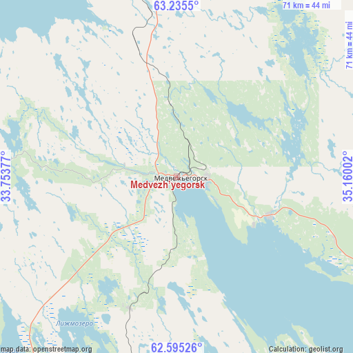
Medvezh’yegorsk GPS coordinates[2]
62° 55' 1.668" North, 34° 27' 24.804" East
| Map corner | latitude | longitude |
|---|---|---|
| Upper-left | 63.2355°, | 33.75377° |
| Center: | 62.91713°, | 34.45689° |
| Lower-right: | 62.59526°, | 35.16002° |
| Map W x H: | 71.2×71.2 km | = 44.2×44.2mi |
| max Lat: | 73.50819° ⇑3.8% North |
| Medvezh’yegorsk: | 62.91713° |
| min Lat: | ⇓96.2% South 41.28413° |
| min Long | Medvezh’yegor | max Long |
| -179.12198° | 34.45689° | 179.35046° |
| W 10.3%⇐ | ⇒89.7% E |
Elevation
Elevation of Medvezh’yegorsk is 43 m = 141 ft, and this is 159.6 m = 524 ft below average elevation for this country.
| Max E: |
2518 m = 8261 ft | 86% |
| Avg. | 202.6 m = 665 ft | |
| Medvezh’yegorsk | 43 m = 141 ft | |
Min E: |
-28 m = -92 ft | 14% |
See also: Russia elevation on elevation.city.
Geographical zone
Medvezh’yegorsk is located in North temperate zone (between Tropic of Cancer and the Arctic Circle). Distance of this North polar circle is 405.4 km =251.9 mi to North.| Distance of | km | miles | from Medvezh’yegorsk |
|---|---|---|---|
| North Pole | 3011.3 | 1871.1 | to North |
| Arctic Circle | 405.4 | 251.9 | to North |
| Tropic Cancer | 4389.8 | 2727.7 | to South |
| Equator | 6995.7 | 4346.9 | to South |


Nearby cities:
15 places around Medvezh’yegorsk: (largest is in red/bold)
• Gimoly
109 km =67.7 mi,  277°
277°
• Girvas
62.6 km =38.9 mi,  218°
218°
• Kondopoga
79.7 km =49.5 mi,  187°
187°
• Matrosy
130.7 km =81.2 mi, 194°
• Nadvoitsy
105.8 km =65.7 mi,  356°
356°
• Petrozavodsk
126 km =78.3 mi,  182°
182°
• Pindushi
6.2 km =3.9 mi,  91°
91°
• Porosozero
90.6 km =56.3 mi,  255°
255°
• Povenets
20.2 km =12.6 mi,  112°
112°
• Segezha
91.9 km =57.1 mi, 355°
• Shun’ga
42.9 km =26.7 mi,  144°
144°
• Shuya
107.9 km =67 mi, 186°
• Sukkozero
110.1 km =68.4 mi, 284°
• Syapsya
123.6 km =76.8 mi,  206°
206°
• Yanishpole
90.1 km =56 mi, 186°
Sources, notices
• [Note1] Compared only with cities in Russia existing in our database
• [Src1] Map data: © OpenStreetMap contributors (CC-BY-SA)
• [Src2] Other city data from geonames.org with taken over terms of usage.
• [Src3] Geographical zone / Annual Mean Temperature by Robert A. Rohde @ Wikipedia
