Poretskoye geodata
Poretskoye (Chuvashia) is a populated place; located in Russia in Europe/Moscow (GMT+3) time zone. With population of 6,420 people, there are 2148 cities with bigger population in this country. Compared to other cities in Russia, 55.3% of cities are located further ↓South; 53.7% of cities are located further ←West and 65% of cities have higher elevation than Poretskoye. Note1


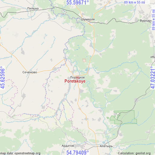
Poretskoye GPS coordinates[2]
55° 11' 50.712" North, 46° 19' 44.688" East
| Map corner | latitude | longitude |
|---|---|---|
| Upper-left | 55.59671°, | 45.62596° |
| Center: | 55.19742°, | 46.32908° |
| Lower-right: | 54.79409°, | 47.03221° |
| Map W x H: | 89.2×89.2 km | = 55.4×55.4mi |
| max Lat: | 73.50819° ⇑44.7% North |
| Poretskoye: | 55.19742° |
| min Lat: | ⇓55.3% South 41.28413° |
| min Long | Poretskoye | max Long |
| -179.12198° | 46.32908° | 179.35046° |
| W 53.7%⇐ | ⇒46.3% E |
Elevation
Elevation of Poretskoye is 114 m = 374 ft, and this is 88.6 m = 291 ft below average elevation for this country.
| Max E: |
2518 m = 8261 ft | 65% |
| Avg. | 202.6 m = 665 ft | |
| Poretskoye | 114 m = 374 ft | |
Min E: |
-28 m = -92 ft | 35% |
See also: Russia elevation on elevation.city.
Geographical zone
Poretskoye is located in North temperate zone (between Tropic of Cancer and the Arctic Circle). Distance of this North polar circle is 1263.8 km =785.3 mi to North.| Distance of | km | miles | from Poretskoye |
|---|---|---|---|
| North Pole | 3869.7 | 2404.5 | to North |
| Arctic Circle | 1263.8 | 785.3 | to North |
| Tropic Cancer | 3531.5 | 2194.4 | to South |
| Equator | 6137.4 | 3813.6 | to South |


Nearby cities:
15 places around Poretskoye: (largest is in red/bold)
• Alatyr’
42.7 km =26.5 mi,  157°
157°
• Alikovo
65.9 km =40.9 mi,  24°
24°
• Ardatov
39.3 km =24.4 mi,  188°
188°
• Buinsk
46.4 km =28.8 mi,  90°
90°
• Ibresi
46.4 km =28.8 mi,  75°
75°
• Kirya
36.2 km =22.5 mi,  110°
110°
• Krasnaya Gorka
25.2 km =15.7 mi,  326°
326°
• Krasnyye Chetai
55.9 km =34.7 mi,  347°
347°
• Pil’na
47.3 km =29.4 mi, 327°
• Sechenovo
28 km =17.4 mi,  276°
276°
• Sergach
65.9 km =40.9 mi,  304°
304°
• Shumerlya
34.1 km =21.2 mi,  8°
8°
• Turgenevo
39.1 km =24.3 mi,  179°
179°
• Urazovka
50.4 km =31.3 mi, 296°
• Vurnary
51.7 km =32.1 mi,  50°
50°
Sources, notices
• [Note1] Compared only with cities in Russia existing in our database
• [Src1] Map data: © OpenStreetMap contributors (CC-BY-SA)
• [Src2] Other city data from geonames.org with taken over terms of usage.
• [Src3] Geographical zone / Annual Mean Temperature by Robert A. Rohde @ Wikipedia
